Approximate Location Map
Large Map »
Latitude: 51.4614 / 51°27'41"N
Longitude: -0.221 / 0°13'15"W
OS Eastings: 523685
OS Northings: 175108
OS Grid: TQ236751
Mapcode National: GBR BJ.NZ1
Mapcode Global: VHGR4.4J0J
Plus Code: 9C3XFQ6H+HJ
Entry Name: Table Tomb Inscribed to Joseph Lucas
Listing Date: 7 April 1983
Grade: II
Source: Historic England
Source ID: 1065498
English Heritage Legacy ID: 207158
ID on this website: 101065498
Location: Putney, Wandsworth, London, SW15
County: London
District: Wandsworth
Electoral Ward/Division: East Putney
Parish: Non Civil Parish
Built-Up Area: Wandsworth
Traditional County: Surrey
Lieutenancy Area (Ceremonial County): Greater London
Church of England Parish: Putney
Church of England Diocese: Southwark
Tagged with: Building
UPPER RICHMOND ROAD SW15 RICHMOND ROAD SW15
1.
5033
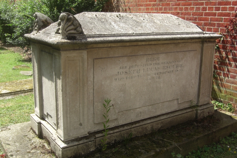
St Mary's Burial Ground
Table tomb inscribed to
Joseph Lucas
TQ 2375 5/6
II GV
2.
Dated 1833. Stone. Greek Revival with plinth, angle piers, hipped cap having
anthemion acroteria at the angles.
Listing NGR: TQ2368575108
External links are from the relevant listing authority and, where applicable, Wikidata. Wikidata IDs may be related buildings as well as this specific building. If you want to add or update a link, you will need to do so by editing the Wikidata entry.


Other nearby listed buildings
