Approximate Location Map
Large Map »
Latitude: 51.5088 / 51°30'31"N
Longitude: -0.1528 / 0°9'10"W
OS Eastings: 528290
OS Northings: 180497
OS Grid: TQ282804
Mapcode National: GBR 9F.W9
Mapcode Global: VHGQZ.9BLN
Plus Code: 9C3XGR5W+GV
Entry Name: 6, Aldford Street W1
Listing Date: 9 January 1970
Grade: II
Source: Historic England
Source ID: 1357165
English Heritage Legacy ID: 208531
ID on this website: 101357165
Location: Mayfair, Westminster, London, W1K
County: London
District: City of Westminster
Electoral Ward/Division: West End
Parish: Non Civil Parish
Built-Up Area: City of Westminster
Traditional County: Middlesex
Lieutenancy Area (Ceremonial County): Greater London
Church of England Parish: St George, Hanover Square
Church of England Diocese: London
Tagged with: Building
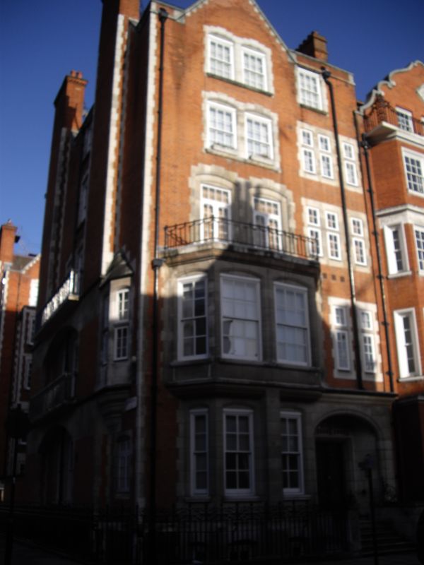
TQ 2880 NW and SW CITY OF WESTMINSTER ALDFORD STREET, W1
68/85 ;79/3
No. 6
9.1.70
G.V. II
Corner terrace house. 1896-97, by Balfour and Turner. Red brick with
Portland stone dressings, slate roof. Free style Queen Anne with
slightly Jacobethan details. 5 storeys and basement. Slightly
asymmetrical arrangement of 2 window bays. Stone corniced porch to
right, with depressed moulded arched entrance, has stonework run in to
face of half-canted stone bay to left with 2 architraved sash lights
to front, the porch cornice carried over. The canted bay is fully
developed on 1st floor with similar pair of sash lights to front and
one each side; pairs of similar windows in line to upper floors
stone-dressed with architraves and narrower coupled and single lights
to right hand on these floors. The front is finished off with a
parapet and stone coped gable over major left hand bay. Return
elevation has 2 large corbelled external chimney stacks, linked by
wide segmental arches with balconies to ground and 1st floors,
irregular fenestration with small oriel butting stack to right on 1st
floor. Gabled rear elevation. Stone coped screen wall and wrought
iron area railings link up with those of similarly designed No. 78
Mount Street. Part of island block development by Balfour and Turner
as part of their Grosvenor Estate improvements.
Survey of London; Vol. XL.
Listing NGR: TQ2829080497
External links are from the relevant listing authority and, where applicable, Wikidata. Wikidata IDs may be related buildings as well as this specific building. If you want to add or update a link, you will need to do so by editing the Wikidata entry.


Other nearby listed buildings
