Approximate Location Map
Large Map »
Latitude: 51.5127 / 51°30'45"N
Longitude: -0.1459 / 0°8'45"W
OS Eastings: 528754
OS Northings: 180935
OS Grid: TQ287809
Mapcode National: GBR CC.DX
Mapcode Global: VHGQZ.F76Q
Plus Code: 9C3XGV73+3J
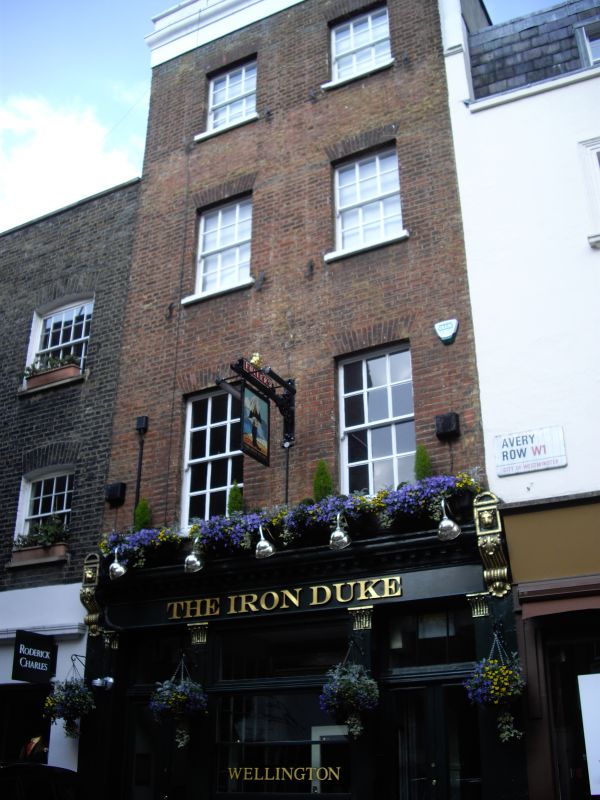
Entry Name: 11, Avery Row W1
Listing Date: 8 March 1976
Grade: II
Source: Historic England
Source ID: 1217843
English Heritage Legacy ID: 208568
ID on this website: 101217843
Location: Mayfair, Westminster, London, W1K
County: London
District: City of Westminster
Electoral Ward/Division: West End
Parish: Non Civil Parish
Built-Up Area: City of Westminster
Traditional County: Middlesex
Lieutenancy Area (Ceremonial County): Greater London
Church of England Parish: St George, Hanover Square
Church of England Diocese: London
Tagged with: Building
TQ 2880 NE CITY OF WESTMINSTER AVERY ROW W1
69/8
8.3.76 No 11
GV
II
House. Early C19 altered brick with stucco cornice and parapet. Four storeys. Two
windows. Late C20 shop front. Above: revealed sashes with glazing bars.
Listing NGR: TQ2879080923
External links are from the relevant listing authority and, where applicable, Wikidata. Wikidata IDs may be related buildings as well as this specific building. If you want to add or update a link, you will need to do so by editing the Wikidata entry.


Other nearby listed buildings
