Approximate Location Map
Large Map »
Latitude: 53.5617 / 53°33'42"N
Longitude: -2.5269 / 2°31'36"W
OS Eastings: 365193
OS Northings: 407359
OS Grid: SD651073
Mapcode National: GBR BWS7.QY
Mapcode Global: WH97T.4QYX
Plus Code: 9C5VHF6F+M6
Entry Name: Church of St John the Evangelist
Listing Date: 9 August 1966
Grade: II
Source: Historic England
Source ID: 1067314
English Heritage Legacy ID: 210564
ID on this website: 101067314
Location: St John's Church, Wingates, Bolton, Greater Manchester, BL5
County: Bolton
Civil Parish: Westhoughton
Built-Up Area: Westhoughton
Traditional County: Lancashire
Lieutenancy Area (Ceremonial County): Greater Manchester
Church of England Parish: Wingates St John the Evangelist
Church of England Diocese: Manchester
Tagged with: Church building
SD 60 NE
8/84
WESTHOUGHTON
Wingates
CHORLEY ROAD (north side)
Church of St. John the Evangelist
9/8/66
II
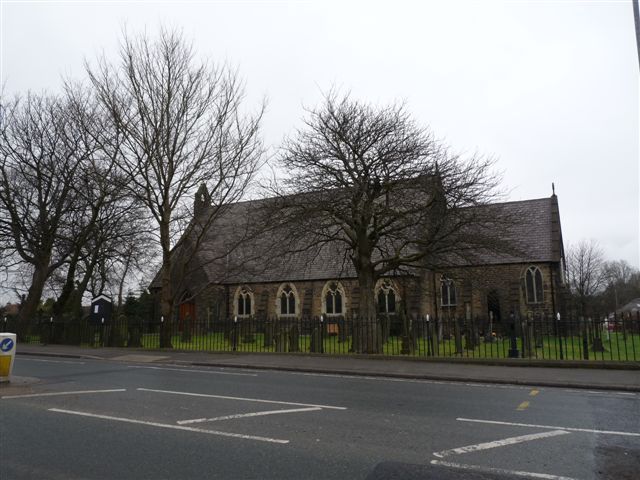
Church. 1858-9. By G. Shaw. Rock-faced stone with ashlar dressings and slate roofs. Nave, chancel and north vestry. Six-bay nave is wide, with low walls; two-light traceried windows between weathered buttresses. South gabled porch with segmental-pointed entrance and light over. West end has three-light window with pentangle in roundel and two trefoil-headed windows; two small buttresses. Bell cote to gable. Chancel has diagonal buttresses flanking three-light east window. South side has window of trefoil-headed lights with trefoils above and Y-tracery window flanking entrance with shouldered lintel. North lean-to vestry has triple pointed lights and entrance; brick stack on stone base.
Interior: roof has braced collar roof with pendants and wind braces. West gallery probably moved forward during late C20 alterations to make vestries and meeting room. Chancel has arch-braced roof, wainscotting and traceried reredos. C19 stained glass, good to east and south.
Listing NGR: SD6519307359
External links are from the relevant listing authority and, where applicable, Wikidata. Wikidata IDs may be related buildings as well as this specific building. If you want to add or update a link, you will need to do so by editing the Wikidata entry.


Other nearby listed buildings
