Approximate Location Map
Large Map »
Latitude: 53.5298 / 53°31'47"N
Longitude: -2.2857 / 2°17'8"W
OS Eastings: 381156
OS Northings: 403716
OS Grid: SD811037
Mapcode National: GBR DWGM.YD
Mapcode Global: WH983.VJQW
Plus Code: 9C5VGPH7+WP
Entry Name: Sundial in Rectory Grounds
Listing Date: 30 June 1966
Grade: II
Source: Historic England
Source ID: 1067293
English Heritage Legacy ID: 210618
ID on this website: 101067293
Location: Prestwich, Bury, Greater Manchester, M25
County: Bury
Electoral Ward/Division: St Mary's
Parish: Non Civil Parish
Built-Up Area: Manchester
Traditional County: Lancashire
Lieutenancy Area (Ceremonial County): Greater Manchester
Church of England Parish: Prestwich St Mary
Church of England Diocese: Manchester
Tagged with: Sundial
SD 80 SW, CHURCH LANE,
10/113
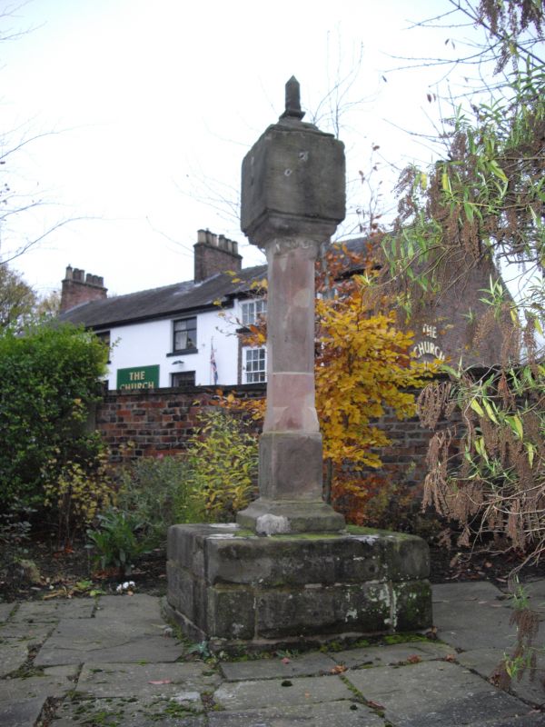
Sundial in Rectory Grounds
30.6.66
GV
II
Probably c1630. Stone. 4-faced sundial on octagonal shaft; square base with
strapwork carvings; plinth. Re-erected from grounds of Deyne Hall. Gnomons
missing.
Listing NGR: SD8115603716
External links are from the relevant listing authority and, where applicable, Wikidata. Wikidata IDs may be related buildings as well as this specific building. If you want to add or update a link, you will need to do so by editing the Wikidata entry.


Other nearby listed buildings
