Approximate Location Map
Large Map »
Latitude: 53.6048 / 53°36'17"N
Longitude: -2.3024 / 2°18'8"W
OS Eastings: 380084
OS Northings: 412074
OS Grid: SD800120
Mapcode National: GBR DVCR.BH
Mapcode Global: WH97Q.LNT9
Plus Code: 9C5VJM3X+W2
Entry Name: Calrows Farmhouse
Listing Date: 21 September 1982
Grade: II
Source: Historic England
Source ID: 1067268
English Heritage Legacy ID: 210655
ID on this website: 101067268
Location: Higher Woodhill, Bury, Greater Manchester, BL8
County: Bury
Electoral Ward/Division: Elton
Parish: Non Civil Parish
Built-Up Area: Bury
Traditional County: Lancashire
Lieutenancy Area (Ceremonial County): Greater Manchester
Church of England Parish: Kirklees Valley
Church of England Diocese: Manchester
Tagged with: Farmhouse
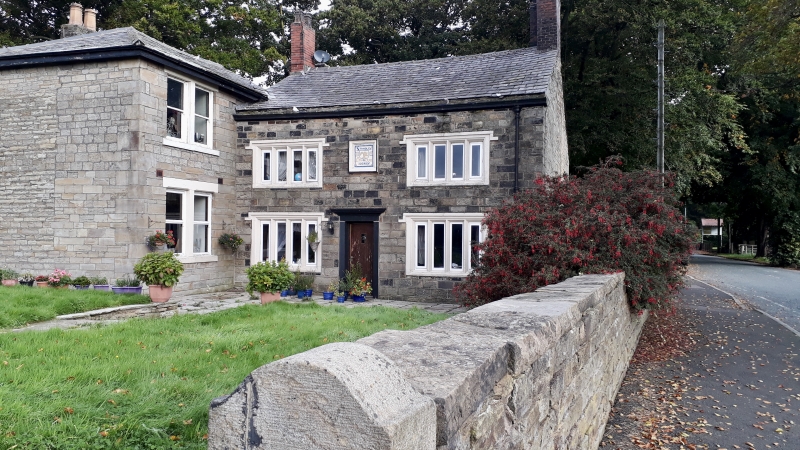
SD 81 SW HIGHER WOODHILL ROAD
6/30
21.9.82 Calrows Farmhouse
- II
Date on moulded, carved panel with crest bedroom upper windows "Stanley/P/LM/1710/Derby"
but probably earlier in part. Main section faces south at right angles to road.
Regularly coursed stone walls. Two storeys. Front elevation has been rebuilt (circa
1982) and has a new four-light mullioned window with dripstone on first and ground
floors each side of central doorway with old date plaque over (see above. Formerly
with an old three and four-light mullioned window above and a sash window and altered
window below). Central doorway; another doorway with shouldered lintel removed.
Decorated cornice. Brick gable chimneys. Rear elevation with old central two-light
mullioned and transomed window (lower part of mullion now in timber); to left hand,
an old, three-light mullioned first floor window and an old four-light mullioned
ground floor window; to right-hand, an old three-light mullioned first floor window
with leaded lights, and a three-light window below, adjoining a doorway. Probably
C18 brick wing adjoining on west. C17 coins said to have been found under floor
of house. Of less interest is two-storey wing at right angles to west of front;
probably early C19 but partially rebuilt in late Victoria period. Paired sash window
above and below in east elevation. Hipped stone slab roof.
Listing NGR: SD8008412074
External links are from the relevant listing authority and, where applicable, Wikidata. Wikidata IDs may be related buildings as well as this specific building. If you want to add or update a link, you will need to do so by editing the Wikidata entry.


Other nearby listed buildings
