Approximate Location Map
Large Map »
Latitude: 53.4111 / 53°24'40"N
Longitude: -2.1575 / 2°9'26"W
OS Eastings: 389629
OS Northings: 390493
OS Grid: SJ896904
Mapcode National: GBR FXCZ.QX
Mapcode Global: WHB9W.TJT9
Plus Code: 9C5VCR6V+F2
Entry Name: 13, Little Underbank, Stockport
Listing Date: 10 March 1975
Last Amended: 21 November 2011
Grade: II
Source: Historic England
Source ID: 1067175
English Heritage Legacy ID: 210827
ID on this website: 101067175
Location: Stockport, Greater Manchester, SK1
County: Stockport
Electoral Ward/Division: Brinnington and Central
Parish: Non Civil Parish
Built-Up Area: Stockport
Traditional County: Cheshire
Lieutenancy Area (Ceremonial County): Greater Manchester
Church of England Parish: Stockport St Mary
Church of England Diocese: Chester
Tagged with: Building
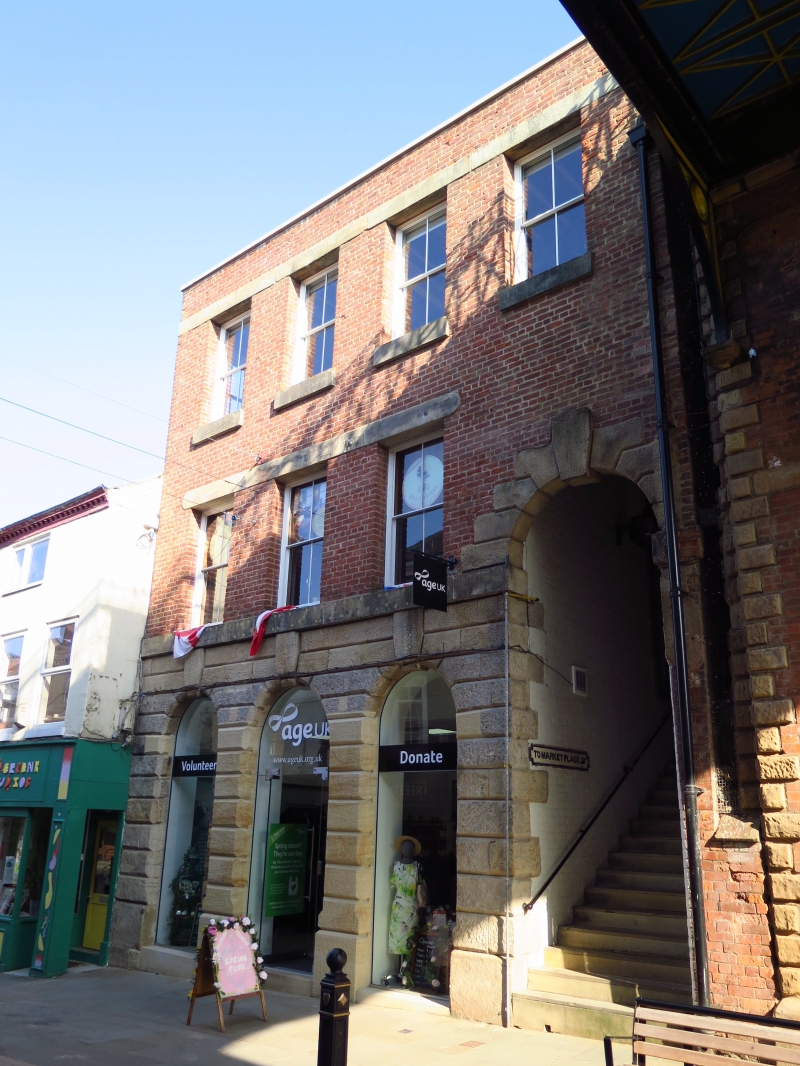
A mid C19 purpose-built commercial premises.
PLAN: Rectangular with passageway though building on right-hand side containing a flight of steps.
EXTERIOR: Three storeys with a flat roof; an upper storey was removed in the C20. The tall ground floor has a rusticated stone surround with three giant keystones and a late C20 shop front. To the right is a tall, rusticated arched opening with giant keystone and steps leading up through an integral passageway beneath the upper floors to the Market Place. It has an iron wall sign reading TO MARKET PLACE. On the first floor are three windows with continuous sill and lintel bands. The second floor has four windows with stone lintels and a continuous flush lintel band. The windows are two-over-two pane hung sashes. The steps have been restored. There are two windows facing onto the stairway and an arched opening towards the top.
The building is structurally distinct from the neighbouring St Petersgate Bridge with which it has group value.
INTERIOR: Not inspected.
This list entry was subject to a Minor Amendment on 24/11/2011
(Formerly listed as Nos 13 & 15)
No.13 Little Underbank was built in the mid C19 as a commercial premises. Little Underbank lies in the natural ravine of Tin Brook to the south side of the Market Place, which caused problems of access to the market. The building incorporated a steep flight of steps up from the street to the Market Place. A route up to the Market Place is shown in this position on a map of 1824 and the building and flight of steps are shown on the 1:1056 Ordnance Survey map of 1849.
* Architectural Interest: As a representative example of a purpose-built urban premises, built in the first half of C19 in a monumental character, with rusticated stone ground floor and archway with giant keystones.
* Historic Interest: Incorporating a flight of steps linking the street, in a ravine, to the Market Place to the north so aiding circulation in a difficult terrain and predating St Petersgate Bridge, which was built to address this problem.
* Group Value: No.13 forms a composition with the adjacent St Petersgate Bridge, which also has pedestrian steps, and Nos.1-25 (odd) form a group of urban commercial premises on one of Stockport's main streets.
External links are from the relevant listing authority and, where applicable, Wikidata. Wikidata IDs may be related buildings as well as this specific building. If you want to add or update a link, you will need to do so by editing the Wikidata entry.


Other nearby listed buildings
