Approximate Location Map
Large Map »
Latitude: 53.4027 / 53°24'9"N
Longitude: -2.9852 / 2°59'6"W
OS Eastings: 334592
OS Northings: 389990
OS Grid: SJ345899
Mapcode National: GBR 74Q.77
Mapcode Global: WH877.3QQT
Plus Code: 9C5VC237+3W
Entry Name: 1 and 3, Duke Street L1
Listing Date: 14 March 1975
Grade: II*
Source: Historic England
Source ID: 1356348
English Heritage Legacy ID: 214032
ID on this website: 101356348
Location: Liverpool, Merseyside, L1
County: Liverpool
Electoral Ward/Division: Riverside
Parish: Non Civil Parish
Built-Up Area: Liverpool
Traditional County: Lancashire
Lieutenancy Area (Ceremonial County): Merseyside
Church of England Parish: Liverpool Our Lady and St Nicholas
Church of England Diocese: Liverpool
Tagged with: Building
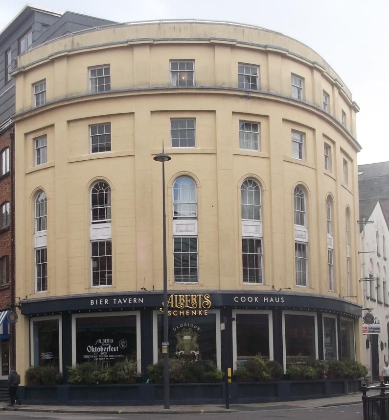
SJ3489 LIVERPOOL DUKE STREET
(North side)
L1
392/30/394 Nos. 1 and 3
14.03.1975
GV II*
Offices and shops, formerly offices and warehouse. Early C19, remodelled by 1849 and further altered mid-late C20. Stuccoed red/brown brick, laid to Flemish bond, beneath a slate roof covering.
PLAN: Street corner site, with curved facade to Duke Street, behind which a double pile twin-pitch roof develops.
FRONT ELEV A TION: Curved facade of 7 bays, 5 storeys, the bays delineated by giant Tuscan pilasters to the upper storeys, then expressed in uppermost floor above intermediate cornice. Ground floor houses wide shop fronts, now blocked, above which first and second floor windows are combined within semi-circular arched headed moulded frames, and incorporating glazing bar sash windows. Above, wide frieze and cornice, and then upper storey with rectangular sash windows below a shallow parapet.
REAR ELEVATION: brick with randomly- located 2 and 3-light windows to upper levels, some barred.
INTERIOR: Radial roof trusses, designed to follow the curve of the building frontage, supporting complex arrangement of purlins, the polygonal interior spaces, resulting from adaptation from an angled to a curved facade retain single rows of columns or posts to each floor, apparently survivals from the former warehouse function.
HISTORY: The building is shown on the Horwood map of Liverpool of 1803, but with an angled corner to the junction of Duke Street and Hanover Street. This is repeated in the Gage map of 1835, but on the Ordnance Survey map of 1849, the building is shown in its present form.
The building forms part of a group, together with No.24. Hanover Street (item 53/575} and Nos 26-30, Hanover Street (item 30/576 }.
An early C19 commercial building made up of offices and warehouse, adapted and remodelled c1840, which forms part of the most significant surviving group of buildings located close to the site of the city's first enclosed dock, and associated with the early phase of Liverpool's development as a seaport of international significance. The group forms a townscape element of great historic and strategic significance.
Listing NGR: SJ3459289990
External links are from the relevant listing authority and, where applicable, Wikidata. Wikidata IDs may be related buildings as well as this specific building. If you want to add or update a link, you will need to do so by editing the Wikidata entry.


Other nearby listed buildings
