Approximate Location Map
Large Map »
Latitude: 53.3439 / 53°20'38"N
Longitude: -2.8582 / 2°51'29"W
OS Eastings: 342957
OS Northings: 383346
OS Grid: SJ429833
Mapcode National: GBR 8YGS.Z0
Mapcode Global: WH87P.266T
Plus Code: 9C5V84VR+HP
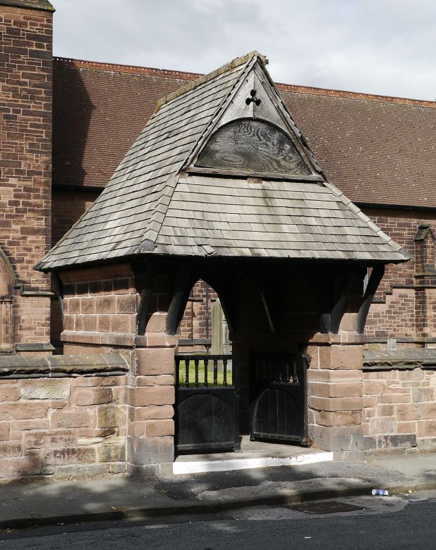
Entry Name: Lychgate to All Saints Church
Listing Date: 14 March 1975
Grade: II
Source: Historic England
Source ID: 1343616
English Heritage Legacy ID: 214227
ID on this website: 101343616
Location: All Saints' Church, Speke, Liverpool, Merseyside, L24
County: Liverpool
Electoral Ward/Division: Speke-Garston
Parish: Non Civil Parish
Built-Up Area: Liverpool
Traditional County: Lancashire
Lieutenancy Area (Ceremonial County): Merseyside
Church of England Parish: Speke St Aidan
Church of England Diocese: Liverpool
Tagged with: Lychgate
SJ 48 SW HALE ROAD
L24
10/564 + 11 Lychgate to
All Saints
Church.
14.3.75
GV II
Lychgate. c.1876. Timber on stone side walls; hipped
shingle roof with gablets and tile cresting. Bracketed
eaves to north and south. Crown post roof with arch-braced
tie beams. Inserted ceiling partly missing (1984).
Listing NGR: SJ4295783346
External links are from the relevant listing authority and, where applicable, Wikidata. Wikidata IDs may be related buildings as well as this specific building. If you want to add or update a link, you will need to do so by editing the Wikidata entry.


Other nearby listed buildings
