Approximate Location Map
Large Map »
Latitude: 53.4836 / 53°29'0"N
Longitude: -2.8938 / 2°53'37"W
OS Eastings: 340784
OS Northings: 398915
OS Grid: SJ407989
Mapcode National: GBR 8X74.9Y
Mapcode Global: WH86W.JP6R
Plus Code: 9C5VF4M4+CF
Entry Name: Kirkby Hall Lodge
Listing Date: 20 June 1975
Grade: II
Source: Historic England
Source ID: 1199017
English Heritage Legacy ID: 215187
ID on this website: 101199017
Location: Kirkby, Knowsley, Merseyside, L32
County: Knowsley
Electoral Ward/Division: Whitefield
Parish: Non Civil Parish
Built-Up Area: Kirkby
Traditional County: Lancashire
Lieutenancy Area (Ceremonial County): Merseyside
Church of England Parish: Kirkby St Chad
Church of England Diocese: Liverpool
Tagged with: Gatehouse
OLD HALL LANE
1.
5090
Kirkby Hall Lodge
SJ 49 NW 1/15
II GV
2.
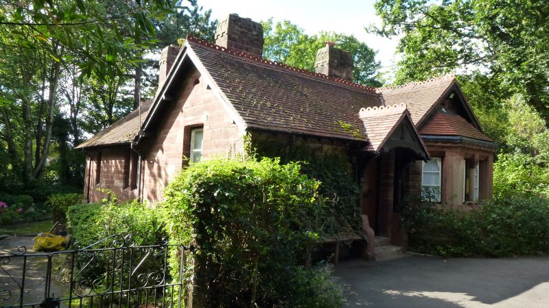
Red sandstone, probably circa 1840, tiled roof, single storey, stone chimney,
gabled porch, stone mullioned windows in gables, and a bay window. Ornamental
cresting to roof.
The Church of St Chad, the Vicarage with its Stables and Gate piers form a group
with Kirkby Hall Lodge.
Listing NGR: SJ4078498915
External links are from the relevant listing authority and, where applicable, Wikidata. Wikidata IDs may be related buildings as well as this specific building. If you want to add or update a link, you will need to do so by editing the Wikidata entry.


Other nearby listed buildings
