Approximate Location Map
Large Map »
Latitude: 52.4705 / 52°28'13"N
Longitude: -1.8846 / 1°53'4"W
OS Eastings: 407932
OS Northings: 285847
OS Grid: SP079858
Mapcode National: GBR 63D.S8
Mapcode Global: VH9Z3.950F
Plus Code: 9C4WF4C8+64
Entry Name: Parkview House
Listing Date: 8 July 1982
Grade: II
Source: Historic England
Source ID: 1343317
English Heritage Legacy ID: 216725
Also known as: Paragon Hotel
ID on this website: 101343317
Location: Deritend, Birmingham, West Midlands, B12
County: Birmingham
Parish: Non Civil Parish
Built-Up Area: Birmingham
Traditional County: Warwickshire
Lieutenancy Area (Ceremonial County): West Midlands
Church of England Parish: Highgate
Church of England Diocese: Birmingham
ALCESTER STREET
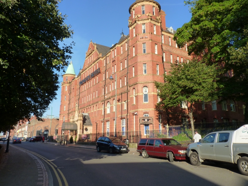
1.
5104 Highgate B12
Parkview House
SP 08 NE 7/66
II
2.
1903-4 built as a massive Rowton House hostel on a scale and with a social
purpose as characteristic of the city at this date as is the quality of the
materials and the decorative finish. A vast quadriangular block of bright
red quality brick with 5 storeys basement and attics. One long narrow windowed
elevation articulated by shallow breaks with broad gables and triangular
ribs rising from second floor sill course. The massiveness of the block is
enlivened by good buff terracota dressings and finials, with the feature of
octagonal corner towers slightly stepped at each stage and crowned by copper
sheathed conical roofs. There is decorative terracota work in the gables
and terracota dragons with shields as gargoyles to the top stage of the towers.
The gabled porch is entirely terracota faced with flanking to cupola capped
octagonal turrets. The central finial is surmounted by a finely modelled
figure of a boy bearing what was probably a light fitting on his back whilst
in the spandrels of the door arch are delicately wrought relief panels with
boys of similar type representing industry and rural poverty or farming life.
Tall cast iron railings to area. Commanding hillside site.
Listing NGR: SP0732485648
External links are from the relevant listing authority and, where applicable, Wikidata. Wikidata IDs may be related buildings as well as this specific building. If you want to add or update a link, you will need to do so by editing the Wikidata entry.


Other nearby listed buildings
