Approximate Location Map
Large Map »
Latitude: 52.4776 / 52°28'39"N
Longitude: -1.9108 / 1°54'38"W
OS Eastings: 406154
OS Northings: 286638
OS Grid: SP061866
Mapcode National: GBR 5X9.ZQ
Mapcode Global: VH9YW.TZPJ
Plus Code: 9C4WF3HQ+3M
Entry Name: 264 and 265 Broad Street and 2 Gas Street
Listing Date: 8 July 1982
Grade: II
Source: Historic England
Source ID: 1075688
English Heritage Legacy ID: 216826
ID on this website: 101075688
Location: Ladywood, Birmingham, West Midlands, B1
County: Birmingham
Parish: Non Civil Parish
Built-Up Area: Birmingham
Traditional County: Warwickshire
Lieutenancy Area (Ceremonial County): West Midlands
Church of England Parish: Birmingham St Luke
Church of England Diocese: Birmingham
Tagged with: Building
This list entry was subject to a Minor Amendment on 26 February 2021 to update the name and address and to reformat the text to current standards
SP 0686 NW
32/6
City Centre B1
BROAD STREET
Nos 264 and 265
(Formerly listed as Nos 266 and 266X)
GV
II
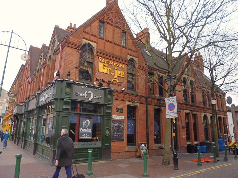
Includes No 2 Gas Street. Circa 1875 by Martin Chamberlain. Red brick with some stone; tiled roof with decorative ridge tiles. Two and three storeys; three bays, that on the left broad and gabled, those on the right narrow and gabled. In a Gothic style. Ground floor with modern shop fronts. Left-hand bay with four first floor sash windows with glazing bars in the upper sashes only and two second floor almost square sash windows with diagonally set bricks between vertical lesenes left, right and over. Right-hand two bays identical: a couplet of pointed arched windows with octofoil set in stone and a little cut brick in the gable above. The right-hand return with entrance to No 2 Gas Street and a left-hand large gable with fine cut brick foliage in the apex and a right-hand smaller gable
similar to the smaller ones on the Broad Street elevation. The building stands astride the Canal.
Listing NGR: SP0615486638
External links are from the relevant listing authority and, where applicable, Wikidata. Wikidata IDs may be related buildings as well as this specific building. If you want to add or update a link, you will need to do so by editing the Wikidata entry.


Other nearby listed buildings
