Approximate Location Map
Large Map »
Latitude: 52.3877 / 52°23'15"N
Longitude: -1.5234 / 1°31'24"W
OS Eastings: 432533
OS Northings: 276735
OS Grid: SP325767
Mapcode National: GBR HBW.B3
Mapcode Global: VHBX4.K70Y
Plus Code: 9C4W9FQG+3J
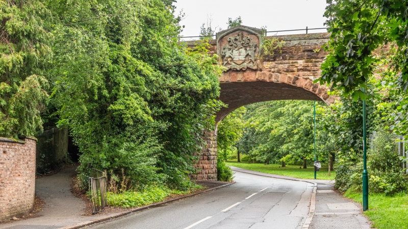
Entry Name: Coat of Arms Bridge
Listing Date: 5 February 1955
Last Amended: 24 June 1974
Grade: II
Source: Historic England
Source ID: 1342924
English Heritage Legacy ID: 218461
ID on this website: 101342924
Location: Stivichall, Coventry, West Midlands, CV3
County: Coventry
Electoral Ward/Division: Earlsdon
Parish: Non Civil Parish
Built-Up Area: Coventry
Traditional County: Warwickshire
Lieutenancy Area (Ceremonial County): West Midlands
Church of England Parish: Styvechale St James
Church of England Diocese: Coventry
Tagged with: Railway bridge
1.
5105 COAT OF ARMS BRIDGE ROAD
------------------------
Coat of Arms Bridge
(Formerly listed under
Stivichall)
SP 37 NW 17/144 5.2.55.
II
2.
Mid C19 stone railway bridge with shield of arms in low relief carving over arch.
Listing NGR: SP3253376735
External links are from the relevant listing authority and, where applicable, Wikidata. Wikidata IDs may be related buildings as well as this specific building. If you want to add or update a link, you will need to do so by editing the Wikidata entry.


Other nearby listed buildings
