Approximate Location Map
Large Map »
Latitude: 52.4256 / 52°25'31"N
Longitude: -1.443 / 1°26'34"W
OS Eastings: 437975
OS Northings: 280986
OS Grid: SP379809
Mapcode National: GBR HXF.3J
Mapcode Global: VHBWZ.Y91F
Plus Code: 9C4WCHG4+6R
Entry Name: Cruck House
Listing Date: 24 June 1974
Grade: II
Source: Historic England
Source ID: 1342913
English Heritage Legacy ID: 218503
ID on this website: 101342913
Location: Walsgrave on Sowe, Coventry, West Midlands, CV2
County: Coventry
Electoral Ward/Division: Henley
Parish: Non Civil Parish
Built-Up Area: Coventry
Traditional County: Warwickshire
Lieutenancy Area (Ceremonial County): West Midlands
Church of England Parish: Walsgrave-on-Sowe St Mary
Church of England Diocese: Coventry
Tagged with: House Thatched cottage
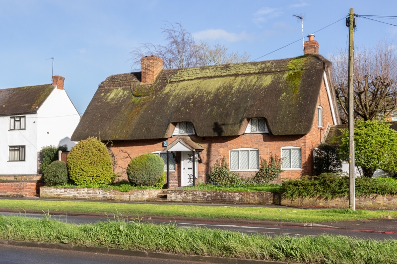
1.
5105 HINCKLEY ROAD, WALSGRAVE
------------------------
No 16
(Cruck House)
SP 3780 NE 23/159
II
2.
Medieval cruck timber frame. Early C19 or late C18 front, of red brick. Thatched
roof. 1 storey and attics, 4 flush casement windows under cambered arches. 2 casement
dormers. (No No. 18).
Listing NGR: SP3797580986
External links are from the relevant listing authority and, where applicable, Wikidata. Wikidata IDs may be related buildings as well as this specific building. If you want to add or update a link, you will need to do so by editing the Wikidata entry.


Other nearby listed buildings
