Approximate Location Map
Large Map »
Latitude: 52.4083 / 52°24'30"N
Longitude: -1.5165 / 1°30'59"W
OS Eastings: 432984
OS Northings: 279036
OS Grid: SP329790
Mapcode National: GBR HCM.VP
Mapcode Global: VHBWY.NQMM
Plus Code: 9C4WCF5M+89
Entry Name: 9, Spon Street
Listing Date: 24 June 1974
Grade: II
Source: Historic England
Source ID: 1076601
English Heritage Legacy ID: 218565
ID on this website: 101076601
Location: Spon End, Coventry, West Midlands, CV1
County: Coventry
Electoral Ward/Division: St Michael's
Parish: Non Civil Parish
Built-Up Area: Coventry
Traditional County: Warwickshire
Lieutenancy Area (Ceremonial County): West Midlands
Church of England Parish: Coventry St John Baptist
Church of England Diocese: Coventry
Tagged with: Building
This list entry was subject to a Minor Amendment on 16/05/2019.
SP 3279 SE
3/49
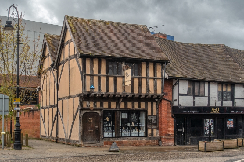
SPON STREET (south side)
No 9
GV
II
Formerly No 7 Much Park Street. Now re-erected and restored.
C16 or earlier timber frame, plaster infilling, tiled roof. Two storeys, first floor oversailing. Casement windows.
All the listed buildings in Spon Street form a group.
External links are from the relevant listing authority and, where applicable, Wikidata. Wikidata IDs may be related buildings as well as this specific building. If you want to add or update a link, you will need to do so by editing the Wikidata entry.


Other nearby listed buildings
