Approximate Location Map
Large Map »
Latitude: 52.4928 / 52°29'33"N
Longitude: -2.0071 / 2°0'25"W
OS Eastings: 399615
OS Northings: 288317
OS Grid: SO996883
Mapcode National: GBR 574.P9
Mapcode Global: VH9YV.5L9X
Plus Code: 9C4VFXVV+45
Entry Name: Langley Maltings
Listing Date: 18 March 1974
Grade: II
Source: Historic England
Source ID: 1279047
English Heritage Legacy ID: 219388
ID on this website: 101279047
Location: Tat Bank, Sandwell, West Midlands, B69
County: Sandwell
Electoral Ward/Division: St Pauls
Parish: Non Civil Parish
Built-Up Area: Oldbury (Sandwell)
Traditional County: Worcestershire
Lieutenancy Area (Ceremonial County): West Midlands
Church of England Parish: Oldbury
Church of England Diocese: Birmingham
Tagged with: Malt house
SANDWELL MB WESTERN ROAD
SO 98 NE
Langley
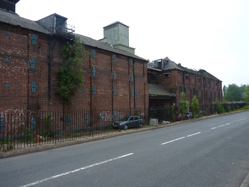
8/167 Langley Maltings
18.3.74
II
Maltings. 1870. Brick with slate roofs. Comprises two parallel three-
storey ranges of malting floors with six kilns at east end, facing Western
Road. West facade faces Titford Canal. The gables of both ranges are of
five bays separated by shallow buttresses with offsets. The windows have
segmental heads. Between the two ranges is a four-storey two-bay kiln, with
a blocked canal arm to each side of it. The gable now projects above the
roof of the southern range, which was replaced by a roof of several shallower
pitches following a fire in the 1920s. At the east end the three northern
kilns have pyramid roofs of steep pitch. The southern kilns have roofs of
shallower pitch. All retain their louvres except for the northern kiln of
the southern range, which is disused. Interior: the malting floors are now
concreted and are supported on three rows of iron columns: Formerly Showell's
Maltings, the buildings are a prominent canalside landmark.
Listing NGR: SO9961588317
External links are from the relevant listing authority and, where applicable, Wikidata. Wikidata IDs may be related buildings as well as this specific building. If you want to add or update a link, you will need to do so by editing the Wikidata entry.


Other nearby listed buildings
