Approximate Location Map
Large Map »
Latitude: 52.6312 / 52°37'52"N
Longitude: 1.2877 / 1°17'15"E
OS Eastings: 622582
OS Northings: 308794
OS Grid: TG225087
Mapcode National: GBR W82.9S
Mapcode Global: WHMTM.R4C5
Plus Code: 9F43J7JQ+F3
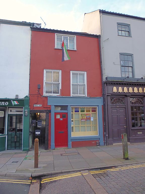
Entry Name: 72, St Benedict's Street
Listing Date: 8 April 1986
Grade: II
Source: Historic England
Source ID: 1051865
English Heritage Legacy ID: 229506
ID on this website: 101051865
Location: Chapelfield Grove, Norwich, Norfolk, NR2
County: Norfolk
District: Norwich
Electoral Ward/Division: Mancroft
Parish: Non Civil Parish
Built-Up Area: Norwich
Traditional County: Norfolk
Lieutenancy Area (Ceremonial County): Norfolk
Church of England Parish: Norwich St Giles
Church of England Diocese: Norwich
Tagged with: Building
TG 2208 NE ST. BENEDICTS STREET
(south side)
15/732
- No. 72
GV II
House, now shop. C18. Rendered facade, pantiled roof. 3 storeys; two
first floor sash windows, three light casement to second floor. Passage
to left hand end, early C20 shop front (altered). Included for group
value.
Listing NGR: TG2258208794
External links are from the relevant listing authority and, where applicable, Wikidata. Wikidata IDs may be related buildings as well as this specific building. If you want to add or update a link, you will need to do so by editing the Wikidata entry.


Other nearby listed buildings
