Approximate Location Map
Large Map »
Latitude: 52.6292 / 52°37'45"N
Longitude: 1.2912 / 1°17'28"E
OS Eastings: 622834
OS Northings: 308579
OS Grid: TG228085
Mapcode National: GBR W8N.8Z
Mapcode Global: WHMTM.T51Q
Plus Code: 9F43J7HR+MF
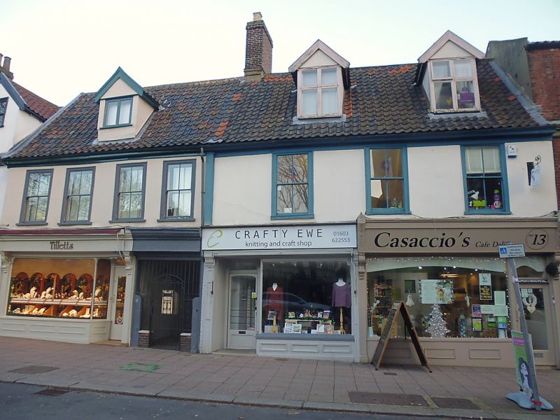
Entry Name: 13-17, St Giles Street
Listing Date: 5 June 1972
Grade: II*
Source: Historic England
Source ID: 1372482
English Heritage Legacy ID: 229523
ID on this website: 101372482
Location: Norwich, Norfolk, NR2
County: Norfolk
District: Norwich
Electoral Ward/Division: Mancroft
Parish: Non Civil Parish
Built-Up Area: Norwich
Traditional County: Norfolk
Lieutenancy Area (Ceremonial County): Norfolk
Church of England Parish: Norwich St Giles
Church of England Diocese: Norwich
Tagged with: Building
TG 2208 NE ST. GILES STREET
(north side)
15/749
5.6.72 Nos. 13 to 17 (odd)
GV II*
Former use unknown, now shops with C15 and early C16 undercrofts.
Shops:- Early C16 with C18 rear additions. Rendered timber frame.
Pantile roof.,2 storey, first floor jettied. 7 irregularly spaced
first floor C18 windows. Three C19 shopfronts, each with side door.
Off-centre carriage entry. 1st floor sash windows with moulded timber
surrounds. 3 gabled dormers. Undercrofts:- Brick. 2 bays ranged at
right angles to the street line with heavy, double order diagonal ribs,
single cross-rib between bays and shallow side chambers. A C19 wall
now divides the 2 bays. Barrel-vaulted passages connect the undercroft
to a later chamber at the west end of the buildings having a pointed
barrel-vault profile at right-angles to the street line. The latter
is one of the very few undercrofts contemporary with the building
above. The building-is graded II* because of the undercrofts, two
of an important group within the City walls.
Listing NGR: TG2283408578
External links are from the relevant listing authority and, where applicable, Wikidata. Wikidata IDs may be related buildings as well as this specific building. If you want to add or update a link, you will need to do so by editing the Wikidata entry.


Other nearby listed buildings
