Approximate Location Map
Large Map »
Latitude: 52.6292 / 52°37'45"N
Longitude: 1.2887 / 1°17'19"E
OS Eastings: 622664
OS Northings: 308577
OS Grid: TG226085
Mapcode National: GBR W88.2K
Mapcode Global: WHMTM.R5WP
Plus Code: 9F43J7HQ+MF
Entry Name: 48, St Giles Street
Listing Date: 26 February 1954
Grade: II*
Source: Historic England
Source ID: 1051842
English Heritage Legacy ID: 229553
ID on this website: 101051842
Location: Chapelfield Grove, Norwich, Norfolk, NR2
County: Norfolk
District: Norwich
Electoral Ward/Division: Mancroft
Parish: Non Civil Parish
Built-Up Area: Norwich
Traditional County: Norfolk
Lieutenancy Area (Ceremonial County): Norfolk
Church of England Parish: Norwich St Giles
Church of England Diocese: Norwich
Tagged with: Building
TG 2208 NE ST. GILES STREET
(south side)
15/779
26.2.54 No. 48
GV II*
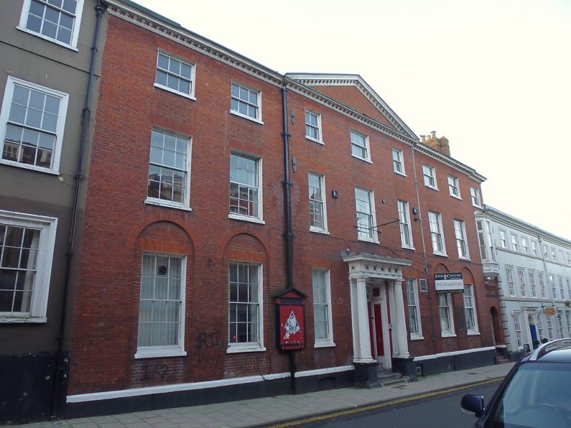
Former house, now hostel with C15 undercroft. Hostel:- C19 Red brick,
plinth and black pantile roof. 3 storeys. 7 bays to principal facade,
one subsidiary bay to right. The 3 central bays project and have a
triangular pediment. Central 4-panel door with rectangular fanlight
containing semi-circular metalwork. 2 detached fluted Tuscan columns
and 2 pilasters supporting frieze having alternate triglyphs and toxophilic
accoutrements. Sash windows throughout with glazing bars and rubbed brick
flat arches, those in the outside ground floor bays contained within recessed
panels with semi-circular arches. Block modillion cornice. The later right-
hand end bay was the entrance to the lecture hall and gymnasion as displayed
in plaque above the doorway. First floor bay window above. Undercroft:-
C15 brick. 2 bays beneath the right-hand half of the building, parallel to
the street line. Each bay has heavy double order diagonal ribs and lighting
niches. The building is graded II* for the undercroft which forms part of
an important group within the City Walls.
Listing NGR: TG2266408576
External links are from the relevant listing authority and, where applicable, Wikidata. Wikidata IDs may be related buildings as well as this specific building. If you want to add or update a link, you will need to do so by editing the Wikidata entry.


Other nearby listed buildings
