Approximate Location Map
Large Map »
Latitude: 52.6319 / 52°37'54"N
Longitude: 1.2975 / 1°17'50"E
OS Eastings: 623243
OS Northings: 308895
OS Grid: TG232088
Mapcode National: GBR W9M.DV
Mapcode Global: WHMTM.X30P
Plus Code: 9F43J7JW+PX
Entry Name: Wright's Court
Listing Date: 5 June 1972
Grade: II
Source: Historic England
Source ID: 1051762
English Heritage Legacy ID: 229749
ID on this website: 101051762
Location: The Close, Norwich, Norfolk, NR3
County: Norfolk
District: Norwich
Electoral Ward/Division: Thorpe Hamlet
Parish: Non Civil Parish
Built-Up Area: Norwich
Traditional County: Norfolk
Lieutenancy Area (Ceremonial County): Norfolk
Church of England Parish: Norwich St George, Tombland
Church of England Diocese: Norwich
Tagged with: Building
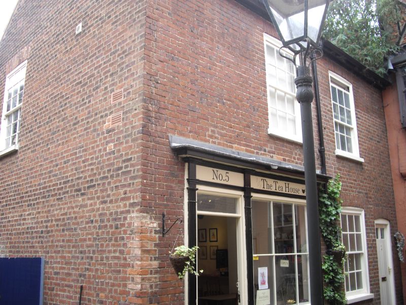
TG 2208 NW WRIGHT'S COURT
(off Elm Hill)
16/965
Nos 4 and 5
5.6.72
GV II
House(s), now shops. C19. Brick with pantile roof. 2 storeys; 2 first-floor
windows. One C19-style with shop window with part-glazed door to left.
Included for group value only.
Listing NGR: TG2324308895
External links are from the relevant listing authority and, where applicable, Wikidata. Wikidata IDs may be related buildings as well as this specific building. If you want to add or update a link, you will need to do so by editing the Wikidata entry.


Other nearby listed buildings
