Approximate Location Map
Large Map »
Latitude: 52.4143 / 52°24'51"N
Longitude: -0.6436 / 0°38'36"W
OS Eastings: 492355
OS Northings: 280457
OS Grid: SP923804
Mapcode National: GBR DX4.L3G
Mapcode Global: VHFNS.SLM1
Plus Code: 9C4XC974+PH
Entry Name: The Dukes Arms Farmhouse
Listing Date: 25 October 1951
Last Amended: 19 June 1992
Grade: II
Source: Historic England
Source ID: 1052050
English Heritage Legacy ID: 231081
ID on this website: 101052050
Location: Grafton Underwood, North Northamptonshire, NN14
County: North Northamptonshire
Civil Parish: Grafton Underwood
Traditional County: Northamptonshire
Lieutenancy Area (Ceremonial County): Northamptonshire
Church of England Parish: Grafton Underwood St James the Apostle
Church of England Diocese: Peterborough
Tagged with: Farmhouse Thatched farmhouse
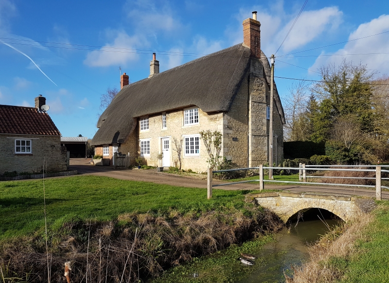
GRAFTON UNDERWOOD
SP9280 The Dukes Arms Farmhouse
1337-0/16/321
25/10/51
(Formerly Listed as:
GRAFTON UNDERWOOD
The Dukes Arms)
GV II
Farmhouse, formerly beer retailers. Dated 1645, later
alteration. Coursed limestone rubble with some brick, thatched
roof, moulded stone ridge stack, and stone and brick endstacks `
(that to right has brick shafts on a slightly projecting stone
chimney with 3 set-offs and diamond-shaped datestone to the
upper part). 2 storeys. Lean-to to left of centre has C20 door
and window in brick infill. One bay to left of this has a C20
ground floor window and a 2-light eyebrow dormer above. To
right of lean-to, the openings are symmetrically arranged: a
central C20 door with ashlar jambs and wooden lintel, with
3-light C20 small-paned casement windows on either side to
ground floor, and similar windows to first floor flanking a
single light window. Flush stone surrounds but wooden lintels.
One-storey gabled wing to rear. Interior not inspected.
Listing NGR: SP9235580457
External links are from the relevant listing authority and, where applicable, Wikidata. Wikidata IDs may be related buildings as well as this specific building. If you want to add or update a link, you will need to do so by editing the Wikidata entry.


Other nearby listed buildings
