Approximate Location Map
Large Map »
Latitude: 52.4826 / 52°28'57"N
Longitude: -0.4782 / 0°28'41"W
OS Eastings: 503444
OS Northings: 288273
OS Grid: TL034882
Mapcode National: GBR FXW.CX7
Mapcode Global: VHFNH.NVLQ
Plus Code: 9C4XFGMC+2P
Entry Name: 27, Benefield Road
Listing Date: 7 June 1974
Grade: II
Source: Historic England
Source ID: 1039846
English Heritage Legacy ID: 231687
ID on this website: 101039846
Location: Oundle, North Northamptonshire, PE8
County: North Northamptonshire
Civil Parish: Oundle
Built-Up Area: Oundle
Traditional County: Northamptonshire
Lieutenancy Area (Ceremonial County): Northamptonshire
Church of England Parish: Oundlew Ashton
Church of England Diocese: Peterborough
Tagged with: Building
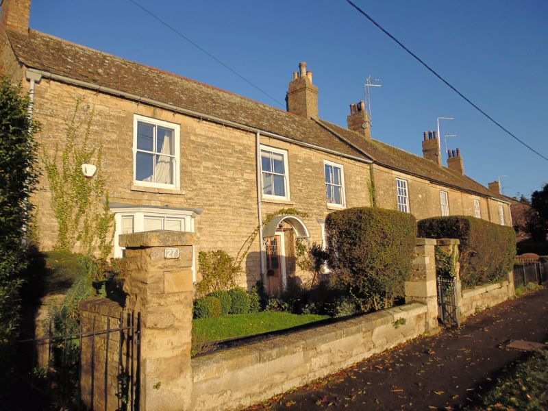
BENEFILED ROAD
1. (North Side)
1483 --------------
No 27
TL 0388 2/106
II GV
2.
Late C18. 2 storeys in coursed rubble with stone slate roof. 3 windows, stone
voussoirs, no glazing bars. 2 canted bays to ground floor and modern door with
segmental hood. Brick chimneys.
The storage premises to west of No 7 and Nos 9 to 20 (odd) form a group.
Listing NGR: TL0344488273
External links are from the relevant listing authority and, where applicable, Wikidata. Wikidata IDs may be related buildings as well as this specific building. If you want to add or update a link, you will need to do so by editing the Wikidata entry.


Other nearby listed buildings
