Approximate Location Map
Large Map »
Latitude: 55.4138 / 55°24'49"N
Longitude: -1.7076 / 1°42'27"W
OS Eastings: 418609
OS Northings: 613353
OS Grid: NU186133
Mapcode National: GBR J5JV.34
Mapcode Global: WHC1K.R612
Plus Code: 9C7WC77R+GX
Entry Name: 14, Fenkle Street
Listing Date: 25 August 1977
Grade: II
Source: Historic England
Source ID: 1041469
English Heritage Legacy ID: 235709
ID on this website: 101041469
Location: Alnwick, Northumberland, NE66
County: Northumberland
Civil Parish: Alnwick
Built-Up Area: Alnwick
Traditional County: Northumberland
Lieutenancy Area (Ceremonial County): Northumberland
Church of England Parish: Alnwick
Church of England Diocese: Newcastle
Tagged with: Building
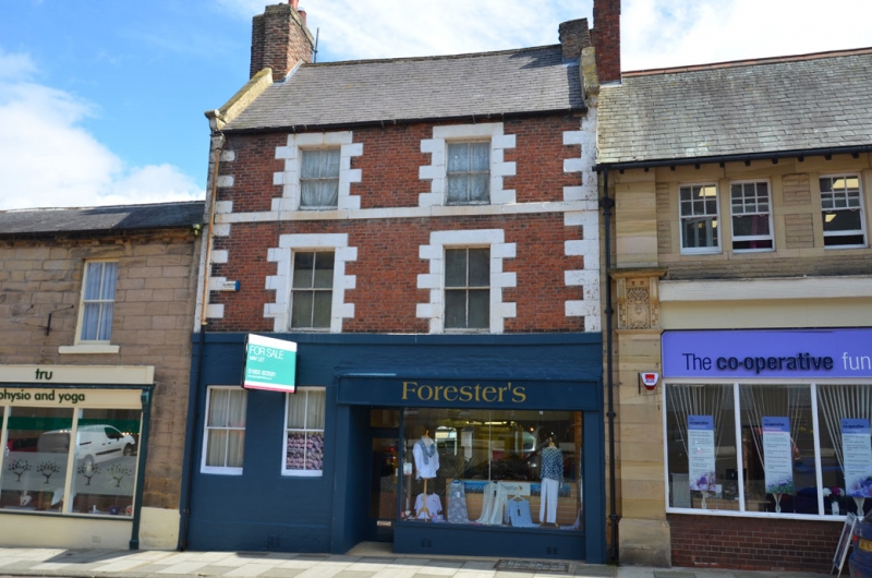
FENKLE STREET
1.
5330
(East Side)
No 14
NU 1813 SE 1/242
II GV
2.
Early C18, 3 storeys and 2 windows. Brick front with stone quoins, quoined dressings,
1st and 2nd floor cill bands and scroll top kneelers to coped verges. Ground floor
painted. Slate roof, 2 shared brick chimneys. Late glazed sash windows. Two
windows on ground floor to left, modern shop front to right.
Listing NGR: NU1861413353
External links are from the relevant listing authority and, where applicable, Wikidata. Wikidata IDs may be related buildings as well as this specific building. If you want to add or update a link, you will need to do so by editing the Wikidata entry.


Other nearby listed buildings
