Approximate Location Map
Large Map »
Latitude: 55.4149 / 55°24'53"N
Longitude: -1.7087 / 1°42'31"W
OS Eastings: 418537
OS Northings: 613485
OS Grid: NU185134
Mapcode National: GBR J5HT.VQ
Mapcode Global: WHC1K.Q5J5
Plus Code: 9C7WC77R+XG
Entry Name: 36, Narrowgate
Listing Date: 25 August 1977
Grade: II
Source: Historic England
Source ID: 1041433
English Heritage Legacy ID: 235807
ID on this website: 101041433
Location: Alnwick, Northumberland, NE66
County: Northumberland
Civil Parish: Alnwick
Built-Up Area: Alnwick
Traditional County: Northumberland
Lieutenancy Area (Ceremonial County): Northumberland
Church of England Parish: Alnwick
Church of England Diocese: Newcastle
Tagged with: Building
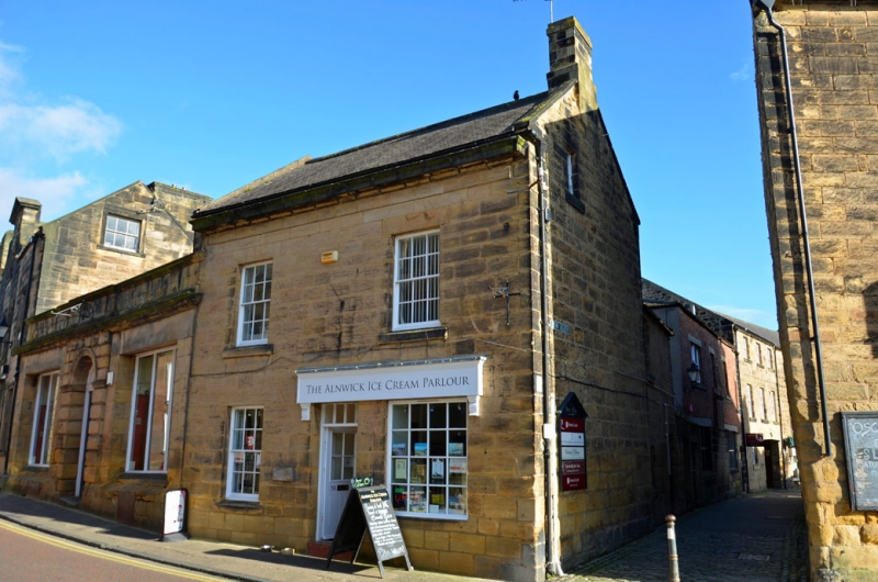
NARROWGATE
1.
5330
(East Side)
No 36
NU 1813 SE 1/67
II GV
2.
Front circa 1830. Two storeys. Two windows. Ashlar, boldly projecting eaves
cornice. Slate roof. Glazing bar sash windows; plate glass window to right on
ground floor. Central flush panel doorway with rectangular light above. Gable
lit attic. Between Nos 34 and 36 Narrowgate runs Bow Alley (qv).
Listing NGR: NU1854313487
External links are from the relevant listing authority and, where applicable, Wikidata. Wikidata IDs may be related buildings as well as this specific building. If you want to add or update a link, you will need to do so by editing the Wikidata entry.


Other nearby listed buildings
