Approximate Location Map
Large Map »
Latitude: 55.1106 / 55°6'38"N
Longitude: -1.499 / 1°29'56"W
OS Eastings: 432058
OS Northings: 579687
OS Grid: NZ320796
Mapcode National: GBR K9ZB.8T
Mapcode Global: WHC30.YTC1
Plus Code: 9C7W4G62+6C
Entry Name: 2 Defence Electric Light Emplacements to East of Link House
Listing Date: 7 April 1988
Grade: II
Source: Historic England
Source ID: 1371407
English Heritage Legacy ID: 236083
ID on this website: 101371407
Location: Northumberland, NE24
County: Northumberland
Civil Parish: Blyth
Built-Up Area: Blyth
Traditional County: Northumberland
Lieutenancy Area (Ceremonial County): Northumberland
Church of England Parish: Blyth St Cuthbert
Church of England Diocese: Newcastle
Tagged with: Building
BLYTH LINKS ROAD
NZ 37 NW
(EAST SIDE)
5/121 2 Defence Electric
light emplacements,
to east of
Link House
GV II
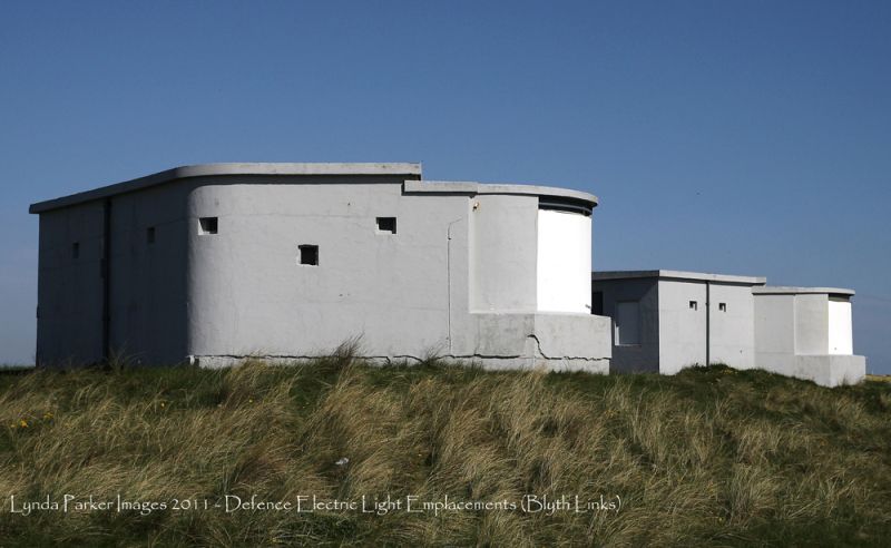
Defence electric light emplacements, 1914-19. Reinforced concrete and steel,
with some brick, whitewashed. Two small rectangular buildings 20 metres apart,
each with a semi-octagonal projection at the seaward corner.
Each has a doorway and boarded window in the landward end, machine gun loops in
the other walls, and boarded openings of curving section in the projection,
under a heavy girder; added brickwork above girder level in emplacement no.1
(southern). The projections have flat roofs of a slightly-lower level to the
low-pitched roof of the main part. The beam produced by a parabola-ellipse
reflector could be directed through an 0.1 metre slit between curved metal
shutters and still illuminate a wide area of sea; the 2 emplacements were
operated by an E.L.O. (Electric Light Officer) in a director station at Link
House Battery (q.v.) 300 metres to the south, and powered by an engine house 50
metres to the west, now a public lavatory (q.v.). Rare survival of a World War
1 coastal defence installation.
Listing NGR: NZ3205879687
External links are from the relevant listing authority and, where applicable, Wikidata. Wikidata IDs may be related buildings as well as this specific building. If you want to add or update a link, you will need to do so by editing the Wikidata entry.


Other nearby listed buildings
