Approximate Location Map
Large Map »
Latitude: 55.4217 / 55°25'18"N
Longitude: -1.6764 / 1°40'35"W
OS Eastings: 420578
OS Northings: 614247
OS Grid: NU205142
Mapcode National: GBR J5QR.V9
Mapcode Global: WHC1D.6ZYJ
Plus Code: 9C7WC8CF+MC
Entry Name: Pant 50 Metres East of Village Hall
Listing Date: 3 December 1969
Last Amended: 25 August 1987
Grade: II
Source: Historic England
Source ID: 1067776
English Heritage Legacy ID: 236389
ID on this website: 101067776
Location: Denwick, Northumberland, NE66
County: Northumberland
Civil Parish: Denwick
Traditional County: Northumberland
Lieutenancy Area (Ceremonial County): Northumberland
Church of England Parish: Alnwick
Church of England Diocese: Newcastle
Tagged with: Building
DENWICK DENWICK VILLAGE
NU 2014
(North side)
22/53 Pant 50 metres
3 .12.69 east of Village Hall
(formerly listed as
Village Pump, in east
half of Village Street
II
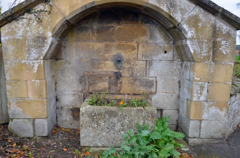
Pant dated 1859 on keystOne. Squared stone with slab coping. Shouldered
segmental arched recess under low-pitched gable contains tap and stone trough.
Listing NGR: NU2057814247
External links are from the relevant listing authority and, where applicable, Wikidata. Wikidata IDs may be related buildings as well as this specific building. If you want to add or update a link, you will need to do so by editing the Wikidata entry.


Other nearby listed buildings
