Approximate Location Map
Large Map »
Latitude: 55.3239 / 55°19'25"N
Longitude: -1.7738 / 1°46'25"W
OS Eastings: 414448
OS Northings: 603335
OS Grid: NU144033
Mapcode National: GBR J61W.RC
Mapcode Global: WHC1X.QGH0
Plus Code: 9C7W86FG+GF
Entry Name: Overgrass Tower and Adjacent Ruins
Listing Date: 31 December 1969
Grade: II
Source: Historic England
Source ID: 1155525
English Heritage Legacy ID: 236872
ID on this website: 101155525
Location: Northumberland, NE65
County: Northumberland
Civil Parish: Newton-on-the-Moor and Swarland
Traditional County: Northumberland
Lieutenancy Area (Ceremonial County): Northumberland
Church of England Parish: Felton St Michael and All Angels
Church of England Diocese: Newcastle
Tagged with: Tower
NU 10 SW
31/12/69
5/203
NEWTON-ON-THE-MOOR
OVERGRASS
Overgrass Tower
and adjacent ruins
II
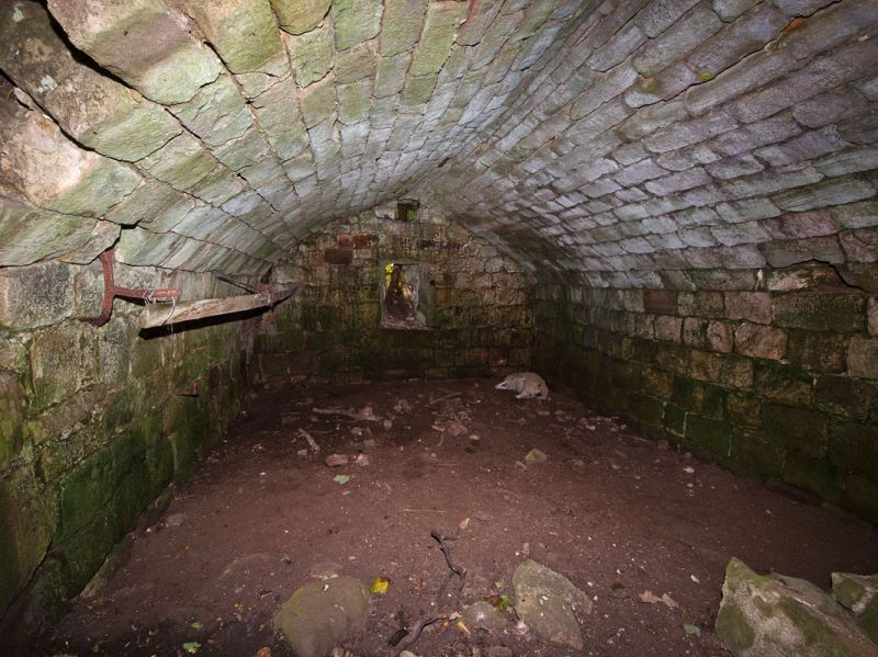
Ruins of towerhouse, late C14 or C15, and adjacent building probably C18.
Tower massive squared stone, adjacent building smaller squared stone.
Rectangular plan 7.15 x 4.7 metres internally with walls 1.8 metres thick and
slight projection for stair alongside entrance at east end of south wall.
Walls stand to about 1st floor level except at south-east corner; the side
walls preserve most of their facing and chamfered set back 2 metres up.
South wall shows west jambs of inner and outer doorways; east wall shows
central loop; west wall shows central loop and garderobe shaft. Interior:
slightly-pointed tunnel vault almost complete, with mural cupboards on south
(bricked up) and east.
Smaller rectangular building adjoins west part of north wall; walls mostly
stand to 3 metres high but without architectural features other than a small
loop and a segment-headed oven recess, formerly at rear of a hearth with
fire hood, on the north.
Listing NGR: NU1444803335
External links are from the relevant listing authority and, where applicable, Wikidata. Wikidata IDs may be related buildings as well as this specific building. If you want to add or update a link, you will need to do so by editing the Wikidata entry.


Other nearby listed buildings
