Approximate Location Map
Large Map »
Latitude: 55.3492 / 55°20'57"N
Longitude: -1.6127 / 1°36'45"W
OS Eastings: 424657
OS Northings: 606197
OS Grid: NU246061
Mapcode National: GBR K65L.N8
Mapcode Global: WHC1T.6T93
Plus Code: 9C7W89XP+MW
Entry Name: Churchyard Walls, Gate and War Memorial
Listing Date: 1 September 1988
Grade: II
Source: Historic England
Source ID: 1303431
English Heritage Legacy ID: 237195
ID on this website: 101303431
Location: St Lawrence's Church, Warkworth, Northumberland, NE65
County: Northumberland
Civil Parish: Warkworth
Built-Up Area: Warkworth
Traditional County: Northumberland
Lieutenancy Area (Ceremonial County): Northumberland
Church of England Parish: Warkworth St Lawrence
Church of England Diocese: Newcastle
Tagged with: Churchyard wall
NU 2406 WARKWORTH DIAL PLACE
(North end)
21/304 Churchyard walls,
gate and War
Memorial
GV II
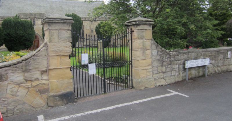
Churchyard walls, gate and war memorial. Wall probably mostly C18,
incorporating some earlier fabric; gates early C19; war memorial c.1920 by
M.H. Graham and H. Honeyman, moved to present site c.1960. Wall squared
stone; gates wrought iron; war memorial ashlar and bronze.
South wall 1.5 metres high with flat slab coping ramped up at either side of
gate near west end; square piers, with plinth and moulded pyramidal caps;
holding double gates with patterned half-rail, downswept top rail and spear-
topped bars. Incurved section of wall at south-west corner behind war
memorial: stepped base has added plaque with 1939-45 names below plaque with
names of 1914-18 war dead in keyed surround; frieze and top block, with bronze
roundel and laurel sprays, and cornice. West wall has small gate near centre,
also jambs of blocked gateway and two blocked arches further north. On north
of churchyard is 1.5-metre high retaining wall, battered in profile. East
wall has small gate near centre; north part incorporates end wall of former
tithe barn (converted into cottages c.1900) with 2 slit vents and outline of
original gable visible.
Included for group value.
Listing NGR: NU2465706197
This List entry has been amended to add sources for War Memorials Online and the War Memorials Register. These sources were not used in the compilation of this List entry but are added here as a guide for further reading, 9 February 2017.
External links are from the relevant listing authority and, where applicable, Wikidata. Wikidata IDs may be related buildings as well as this specific building. If you want to add or update a link, you will need to do so by editing the Wikidata entry.


Other nearby listed buildings
