Approximate Location Map
Large Map »
Latitude: 55.6303 / 55°37'49"N
Longitude: -2.0907 / 2°5'26"W
OS Eastings: 394388
OS Northings: 637422
OS Grid: NT943374
Mapcode National: GBR F3VB.5H
Mapcode Global: WH9Z2.VRM2
Plus Code: 9C7VJWJ5+4P
Entry Name: Parson's Tower
Listing Date: 10 March 1988
Grade: II
Source: Historic England
Source ID: 1370989
English Heritage Legacy ID: 238069
ID on this website: 101370989
Location: Ford, Northumberland, TD15
County: Northumberland
Civil Parish: Ford
Traditional County: Northumberland
Lieutenancy Area (Ceremonial County): Northumberland
Church of England Parish: Ford And Etal
Church of England Diocese: Newcastle
Tagged with: Tower
FORD FORD VILLAGE
NT 9437
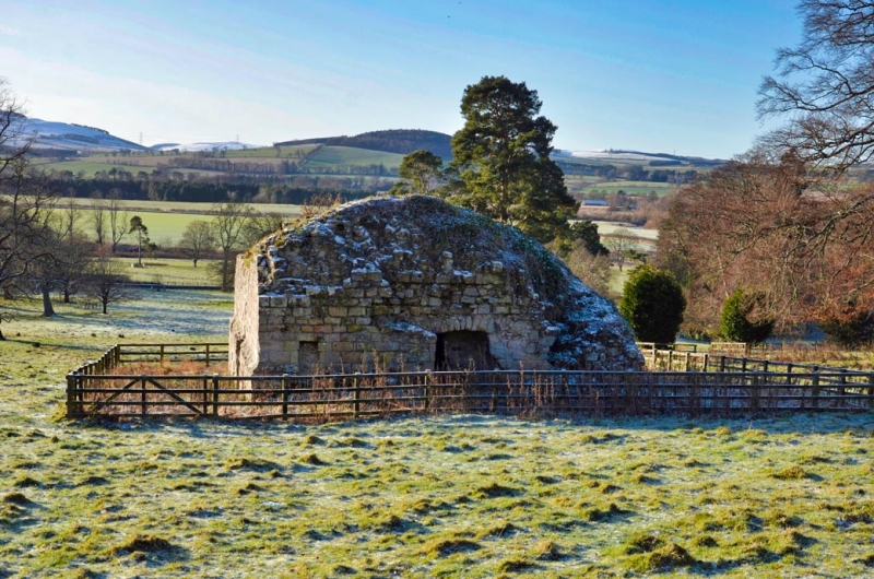
17/102 Parson's Tower
GV II
Ruined tower, probably a 'Vicar's Pele'. Medieval. Squared stone. Ground-
floor entry on south side has been enlarged. Chamfered offset at about 6 ft.
above ground. Walls stand to c.12 ft.
On east side shallow segmental arch to remains of mural stair.
Interior: walls c.7 feet thick. Segmental tunnel-vaulted ground floor.
Northumberland County History: Vol. XI.
Listing NGR: NT9438837422
External links are from the relevant listing authority and, where applicable, Wikidata. Wikidata IDs may be related buildings as well as this specific building. If you want to add or update a link, you will need to do so by editing the Wikidata entry.


Other nearby listed buildings
