Approximate Location Map
Large Map »
Latitude: 55.1683 / 55°10'5"N
Longitude: -1.8599 / 1°51'35"W
OS Eastings: 409021
OS Northings: 586003
OS Grid: NZ090860
Mapcode National: GBR H8GP.44
Mapcode Global: WHC2N.DCK8
Plus Code: 9C7W549R+82
Entry Name: Thornton Headstone 5M South of Chancel of St Andrew's Church
Listing Date: 30 January 1986
Grade: II
Source: Historic England
Source ID: 1304316
English Heritage Legacy ID: 238267
ID on this website: 101304316
Location: St Andrew's Church, Hartburn, Northumberland, NE61
County: Northumberland
Civil Parish: Hartburn
Traditional County: Northumberland
Lieutenancy Area (Ceremonial County): Northumberland
Church of England Parish: Hartburn with Meldon
Church of England Diocese: Newcastle
Tagged with: Tombstone
HARTBURN HARTBURN
NZ 08 NE
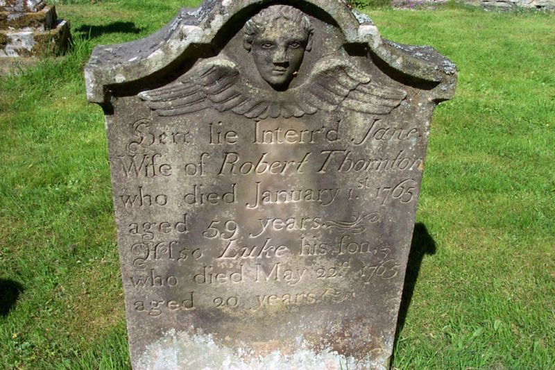
9/28 Thornton headstone 5m
south of chancel of
St. Andrew's church
GV II
Headstone, 1765. Sandstone. Shaped coped top with cherub over inscription
to Jane, wife of Robert Thornton and Luke his son.
Listing NGR: NZ0902186003
External links are from the relevant listing authority and, where applicable, Wikidata. Wikidata IDs may be related buildings as well as this specific building. If you want to add or update a link, you will need to do so by editing the Wikidata entry.


Other nearby listed buildings
