Approximate Location Map
Large Map »
Latitude: 55.2143 / 55°12'51"N
Longitude: -1.6858 / 1°41'8"W
OS Eastings: 420089
OS Northings: 591157
OS Grid: NZ200911
Mapcode National: GBR J8N4.TN
Mapcode Global: WHC2K.26HJ
Plus Code: 9C7W6877+PM
Entry Name: Cockle Park Tower
Listing Date: 30 January 1986
Grade: I
Source: Historic England
Source ID: 1042088
English Heritage Legacy ID: 238298
ID on this website: 101042088
Location: Northumberland, NE61
County: Northumberland
Civil Parish: Hebron
Traditional County: Northumberland
Lieutenancy Area (Ceremonial County): Northumberland
Church of England Parish: Hebron St Cuthbert
Church of England Diocese: Newcastle
Tagged with: Tower house
HEBRON COCKLE PARK
NZ 29 SW NZ 201912
7/65 Cockle Park Tower
I
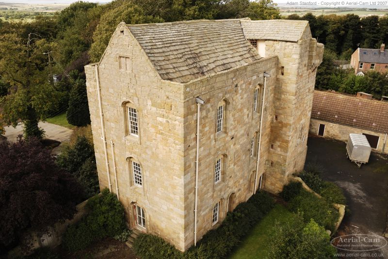
Tower house, early C16 altered C17 and refenestrated c.1790. Squared stone
with dressings; stone flag roof. L-plan with stair turret projecting at
north end of east face and C17 stair projection in centre of west wall.
3 storeys + attic; north end, including turret, has chamfered plinth and
set-back 1st floor, machicolated parapet on north and corbelled-out circular
bartizans at northern angles. East elevation 3 bays; turret set forward to
right has eroded armorial panel (Bertram quartering Ogle) and 3 worn carved
emblems above, with small window and chamfered loops. Section to left has
part-glazed door in 2nd bay and sash windows of 8, 12 or 24 panes; all in
Gothick surrounds with 4-centred arches and hoodmoulds. North elevation has
chamfered loops; gable with partly-blocked 2-light window behind parapet.
South elevation: French window and 24-pane sashes, all in Gothick surrounds
within the jambs of blocked C17 windows; coped gable with blocked 2-light
mullioned window to attic. West elevation 3 bays. Central projection has
boarded door and two 2-light mullioned windows above, the lower blocked. To
left external stair to inserted boarded door breaking 1st floor set back, right
hand part of wall above rebuilt 1828, replacing solar oriel, with 12-pane sash
and old moulded overmantel re-set above. To right of projection blocked 3-light
mullion-and-transom windows with hoodmoulds.
Interior. Divided into 2 dwellings by a brick partition wall in C18; the
southern 2 bays completely remodelled. North end of tower retains barrel vaults
to ground floor and mural chambers, stone newel stair, ground and 1st floor
fireplaces and a well-preserved 2nd-floor garderobe. The southern rooms show
C18 doors, panelled shutters and fireplaces. Attic floor removed; roof with
5 C17 collared principal-rafter trusses.
The tower is thought to have been built c.1520 for Sir William, 4th Lord Ogle,
passing to the Bothal Estates whose later owners became Dukes of Portland.
In the Cl9 it became the centre of the Duke's experimental farm. Under
restoration at time of resurvey.
Articles by R. Bibby in Northumbriana, 11-15 (1977-1979).
Listing NGR: NZ2008991157
External links are from the relevant listing authority and, where applicable, Wikidata. Wikidata IDs may be related buildings as well as this specific building. If you want to add or update a link, you will need to do so by editing the Wikidata entry.


Other nearby listed buildings
