Approximate Location Map
Large Map »
Latitude: 55.1635 / 55°9'48"N
Longitude: -1.7344 / 1°44'3"W
OS Eastings: 417017
OS Northings: 585492
OS Grid: NZ170854
Mapcode National: GBR J8BQ.9V
Mapcode Global: WHC2Q.BGBZ
Plus Code: 9C7W5778+96
Entry Name: Mitford Castle, Remains of Inner Ward and Keep
Listing Date: 20 October 1969
Grade: I
Source: Historic England
Source ID: 1370755
English Heritage Legacy ID: 238931
Also known as: Mitford Castle: a motte and bailey and shell keep castle, medieval chapel, graveyard and field system
ID on this website: 101370755
Location: Mitford, Northumberland, NE61
County: Northumberland
Civil Parish: Mitford
Traditional County: Northumberland
Lieutenancy Area (Ceremonial County): Northumberland
Church of England Parish: Mitford St Mary Magdalene
Church of England Diocese: Newcastle
Tagged with: Castle Motte-and-bailey castle
MITFORD MITFORD
NZ 1785
10/16 Mitford Castle,
remains of inner
20.10.69 ward and keep
GV I
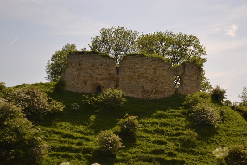
Castle ruins. Late C11 earthwork fortress of Bertram family; curtain of inner
ward early C12, outer ward and chapel late C12, keep early C13. Squared stone,
in places of ashlar quality. Natural hill scarped and ditched to produce motte
carrying irregular oval inner ward containing pentagonal keep, with triangular
outer ward to south and east and barmkin to north-east.
Inner ward: tall curtain,on stepped plinth, remains on west, with large round
arch perhaps to a balcony. Section of wall on east with round arch to outer
ward, is largely C19 reconstruction. Keep stands to 1st floor but external
facing wholly robbed. Basement divided by axial cross wall into 2 barrel-
vaulted chambers; impost band at spring of vault, internal stone spouts (bringing
in rainwater; the chambers were probably intended as cisterns), segmental-arched
doorway to mural stair. 1st floor has chamfered plinth, and is entered via
lobby from external stair. To west of keep footings of possibly earlier
'blockhouse' with splayed arrow loops.
Historical Notes. Described as the "oppidum" of William Bertram in 1138.
Seized by Flemish troops of King John in 1215. In 1315 the scene of kidnappings
and the holding of prisoners to ransom by Sir Gilbert de Middleton. In 1327
described as "wholly burned"; it is uncertain if it was ever restored.
Archaeologia Aeliana 4th series XIV (1937) 74-94 and XXXIII (1955) 27-34.
Listing NGR: NZ1701785492
External links are from the relevant listing authority and, where applicable, Wikidata. Wikidata IDs may be related buildings as well as this specific building. If you want to add or update a link, you will need to do so by editing the Wikidata entry.


Other nearby listed buildings
