Approximate Location Map
Large Map »
Latitude: 54.9788 / 54°58'43"N
Longitude: -2.1277 / 2°7'39"W
OS Eastings: 391925
OS Northings: 564920
OS Grid: NY919649
Mapcode National: GBR FBLW.51
Mapcode Global: WHB2C.932Z
Plus Code: 9C6VXVHC+GW
Entry Name: St Andrew's Cemetery Gates
Listing Date: 18 May 1976
Grade: II
Source: Historic England
Source ID: 1042518
English Heritage Legacy ID: 239233
ID on this website: 101042518
Location: St Andrew's Cemetery, Northumberland, NE46
County: Northumberland
Civil Parish: Hexham
Traditional County: Northumberland
Lieutenancy Area (Ceremonial County): Northumberland
Church of England Parish: Hexham
Church of England Diocese: Newcastle
Tagged with: Building
WEST ROAD
1. (North East Side)
5334
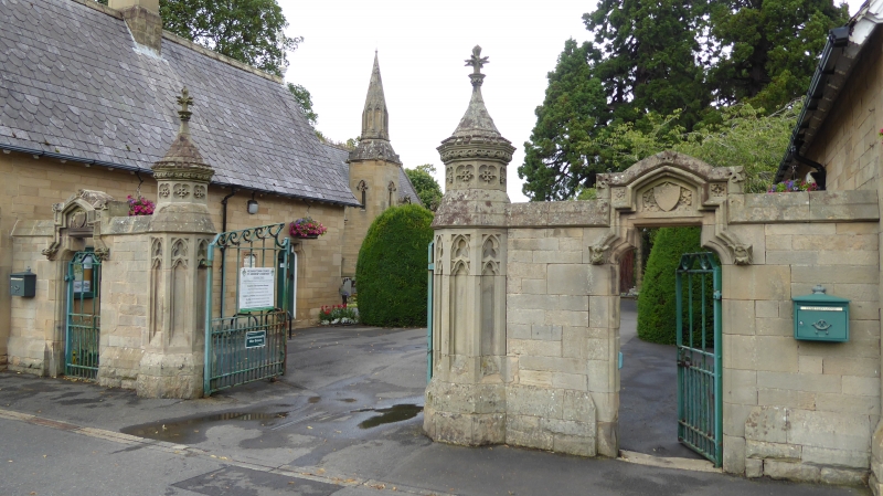
St Andrew's Cemetery Gates
NY 96 SW 3/353A
II
2.
1858-9. Large central gates with smaller gateways to side which have shaped
labels with zoomorphic stops. Octagonal gate piers with blind tracery and crenellated
capping and pinnacles. Cast iron gates.
Listing NGR: NY9192564920
External links are from the relevant listing authority and, where applicable, Wikidata. Wikidata IDs may be related buildings as well as this specific building. If you want to add or update a link, you will need to do so by editing the Wikidata entry.


Other nearby listed buildings
