Approximate Location Map
Large Map »
Latitude: 54.9664 / 54°57'59"N
Longitude: -2.4553 / 2°27'19"W
OS Eastings: 370948
OS Northings: 563624
OS Grid: NY709636
Mapcode National: GBR CC90.7H
Mapcode Global: WH912.8F2J
Plus Code: 9C6VXG8V+HV
Entry Name: Alston Arches Viaduct
Listing Date: 27 July 1987
Grade: II
Source: Historic England
Source ID: 1156068
English Heritage Legacy ID: 240742
Also known as: Haltwhistle Viaduct
ID on this website: 101156068
Location: Haltwhistle, Northumberland, NE49
County: Northumberland
Civil Parish: Haltwhistle
Built-Up Area: Haltwhistle
Traditional County: Northumberland
Lieutenancy Area (Ceremonial County): Northumberland
Church of England Parish: Haltwhistle Holy Cross
Church of England Diocese: Newcastle
Tagged with: Bridge Railway viaduct
NY 76 SW
16/8
HALTWHISTLE
LANTY'S LONNEN
(South end)
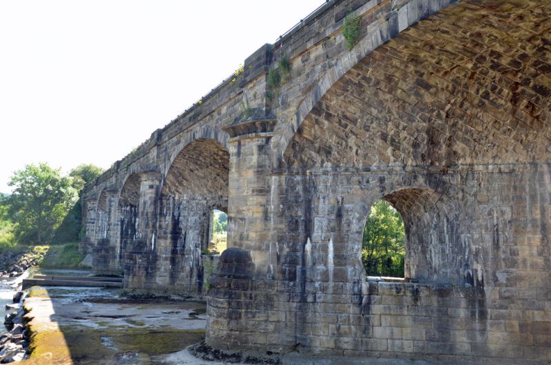
Alston Arches Viaduct
II
Disused railway viaduct over River South Tyne. 1852 by Sir George Barclay Bruce for
the Newcastle and Carlisle Railway Company. Rock-faced dressed stone with ashlar
dressings. Long and low 6-arch viaduct: 4 wide segmental skew arches across river;
semicircular arch at each end across riverside paths. Moulded impost bands.
Cutwaters, on tall rounded plinths, have moulded bases and hollow-chamfered
caps. End arches flanked by slightly-projecting, flat-faced piers. Low
parapet, defined by band at track level, has projecting coping and breaks
forward over piers and cutwaters to form pedestrian refuges. Round-arched
openings cut through supporting cross-walls of each arch (these openings
were intended to be linked by a pedestrian walkway across the river). An
important landscape feature.
(K. Hoole, A Regional History of the Railways of Great Britain Volume 4,
The North East, 1965).
Listing NGR: NY7094863624
External links are from the relevant listing authority and, where applicable, Wikidata. Wikidata IDs may be related buildings as well as this specific building. If you want to add or update a link, you will need to do so by editing the Wikidata entry.


Other nearby listed buildings
