Approximate Location Map
Large Map »
Latitude: 53.4012 / 53°24'4"N
Longitude: -0.9237 / 0°55'25"W
OS Eastings: 471656
OS Northings: 389912
OS Grid: SK716899
Mapcode National: GBR PYZ3.TH
Mapcode Global: WHFFW.SRBY
Plus Code: 9C5XC32G+FG
Entry Name: Wiseton Stables
Listing Date: 25 January 1983
Grade: II
Source: Historic England
Source ID: 1045047
English Heritage Legacy ID: 241201
ID on this website: 101045047
Location: Wiseton, Bassetlaw, Nottinghamshire, DN10
County: Nottinghamshire
District: Bassetlaw
Civil Parish: Wiseton
Traditional County: Nottinghamshire
Lieutenancy Area (Ceremonial County): Nottinghamshire
Church of England Parish: Clayworth
Church of England Diocese: Southwell and Nottingham
Tagged with: Stable
This list entry was subject to a Minor Amendment on 23 February 2022 to update the name and address and reformat the text to current standards
SK 78 NW
7/117
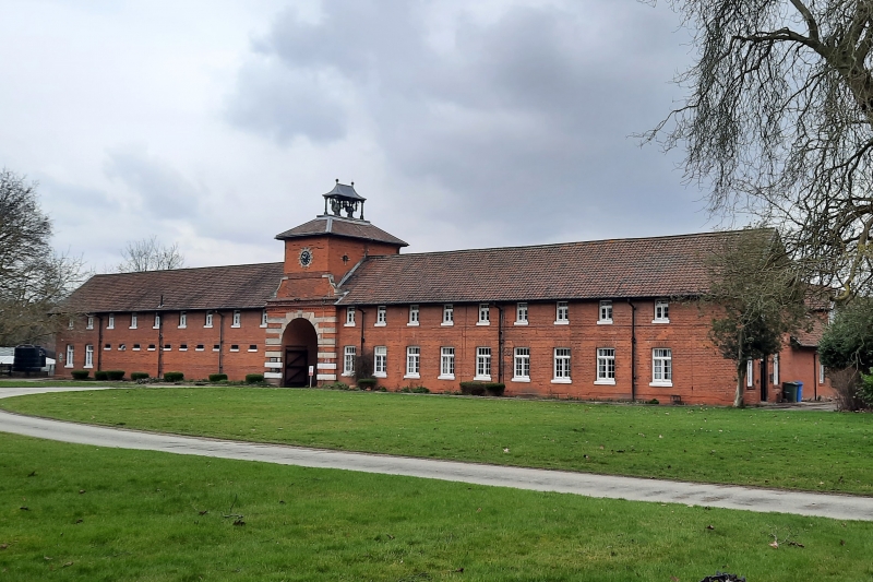
WISETON
MAIN ROAD (north side)
Wiseton Stables
(Formerly listed as Stables at Wiseton Hall, MAIN STREET)
25.1.83
GV.
II
Stable range, 1899. Brick with plain tile, pantile and lead roofs; stone dressings. One single and one double brick bands, dentillated eaves, two ridge stacks, two storeys, twenty bays, enclosed courtyard plan. Projecting central gatehouse has round arched entrance with timber gates and banded rustication; projecting keystones, one inscribed 1899. Above, ashlar coped ramps to first stage with clock in keystoned surround. Pyramidal roof topped by bellcote with six turned wood balusters and lead tent roof with two finials. Flanked to left by ten grilled ventilators with rubbed brick heads. Beyond, two-light mullion and transom casement; above, nine similar casements. To right nine similar casements on either floor, those below with rubbed brick heads. Courtyard has to north fifteen stables; to east fiv stables and groom's house; to south, boundary wall and gateway and carriage house, five bays.
Listing NGR: SK7165689912
External links are from the relevant listing authority and, where applicable, Wikidata. Wikidata IDs may be related buildings as well as this specific building. If you want to add or update a link, you will need to do so by editing the Wikidata entry.


Other nearby listed buildings
