Approximate Location Map
Large Map »
Latitude: 53.2619 / 53°15'42"N
Longitude: -0.7832 / 0°46'59"W
OS Eastings: 481265
OS Northings: 374564
OS Grid: SK812745
Mapcode National: GBR QZZQ.7F
Mapcode Global: WHFGQ.Y87Q
Plus Code: 9C5X7668+PP
Entry Name: Dunham House and attached walls and stable
Listing Date: 1 February 1967
Last Amended: 12 July 1985
Grade: II
Source: Historic England
Source ID: 1045686
English Heritage Legacy ID: 241456
ID on this website: 101045686
Location: Dunham on Trent, Bassetlaw, Nottinghamshire, NG22
County: Nottinghamshire
District: Bassetlaw
Civil Parish: Dunham-on-Trent
Traditional County: Nottinghamshire
Lieutenancy Area (Ceremonial County): Nottinghamshire
Church of England Parish: East Drayton with Dunham-on-Trent, Darlton, Ragnall and Fledborough
Church of England Diocese: Southwell and Nottingham
Tagged with: Building
This list entry was subject to a Minor Amendment on 20 October 2023 to correct a typo in the description and to reformat the text to current standards
SK 87 SW
4/16
DUNHAM-ON-TRENT
MAIN STREET (south side)
Dunham House and attached walls and stable
(Formerly listed as St. Oswald's House)
1.2.67
G.V.
II
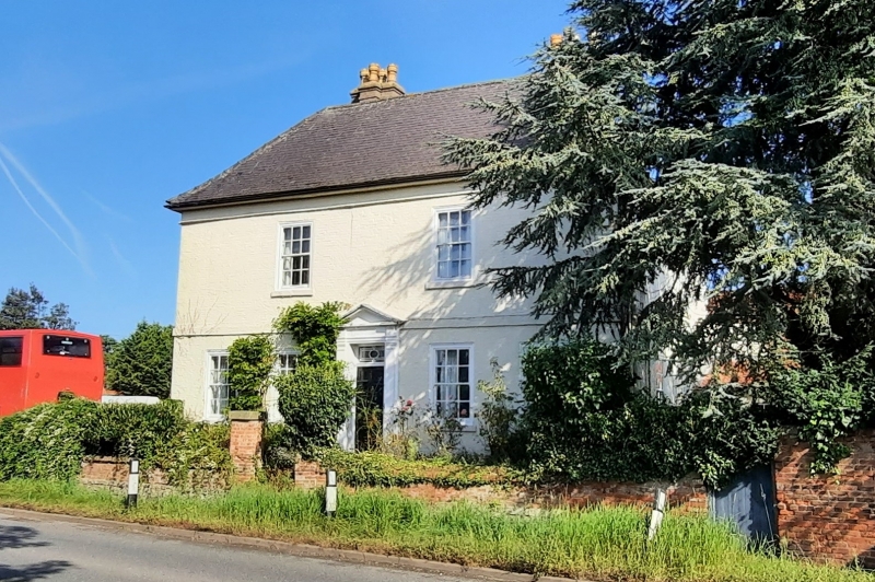
House and attached walls and stable. C17 and mid C18. House refronted C18. Painted render over red brick with a dressed coursed rubble plinth. Steep hipped slate roof. Wooden eaves cornice. Two rendered stacks each with four shafts. Two storeys, five bays with a first floor band. Central doorway, three steps up, with a panelled door and traceried overlight set in reveal and flanked by single fluted Doric pilasters supportinq an entablature with paterae and pediment. Either side are two glazing bar sashes with two similar sashes above. To the riqht, set back, is a singe storey, two bay late C18 red brick and pantile stable with dentil eaves and raised and coped right gable with single pilaster under. Single small glazing bar fixed light with a doorway with stable door to the right. Projecting from the left is a painted brick and pantile lean-to and extending from the right is a single storey four bay red brick and pantile C20 range of outbuildings. To the rear of the house is a lower wing.
Extending from the south west side of the house is a red brick wall on a dressed coursed rubble base with moulded brick coping, after 3 metres this turns at a right angle, drops down and continues eastwards for 12 metres broken by a central gateway which has single piers with ashlar coping and orb finials flanking an iron gate with three semi-circular steps leading down to the pavement. A higher red brick wall with less elaborate coping and broken by a gateway with wooden gate extends eastwards for 17 metres. A similar low wall, broken by a gateway with two ashlar coped piers and an iron gate, extends from the south east corner off the house for 3 metres and meets the front wall.
Interior. The south west room has late C17 bolection moulded panels and fireplace. The north east room has a large fireplace, now part blocked, with bressummer. There is a late C17 dogleg staircase with turned and twisted balusters.
Listing NGR: SK8126574564
External links are from the relevant listing authority and, where applicable, Wikidata. Wikidata IDs may be related buildings as well as this specific building. If you want to add or update a link, you will need to do so by editing the Wikidata entry.


Other nearby listed buildings
