Approximate Location Map
Large Map »
Latitude: 53.1016 / 53°6'5"N
Longitude: -1.0305 / 1°1'49"W
OS Eastings: 465007
OS Northings: 356484
OS Grid: SK650564
Mapcode National: GBR 9H9.J8L
Mapcode Global: WHFHD.49JL
Plus Code: 9C5W4X29+JQ
Entry Name: The Grange
Listing Date: 13 May 1986
Grade: II
Source: Historic England
Source ID: 1193690
English Heritage Legacy ID: 242123
ID on this website: 101193690
Location: Farnsfield, Newark and Sherwood, Nottinghamshire, NG22
County: Nottinghamshire
District: Newark and Sherwood
Civil Parish: Farnsfield
Built-Up Area: Farnsfield
Traditional County: Nottinghamshire
Lieutenancy Area (Ceremonial County): Nottinghamshire
Church of England Parish: Farnsfield
Church of England Diocese: Southwell and Nottingham
Tagged with: Building
SK 65 NE
3/68
FARNSFIELD
MAIN STREET
(south side)
The Grange
II
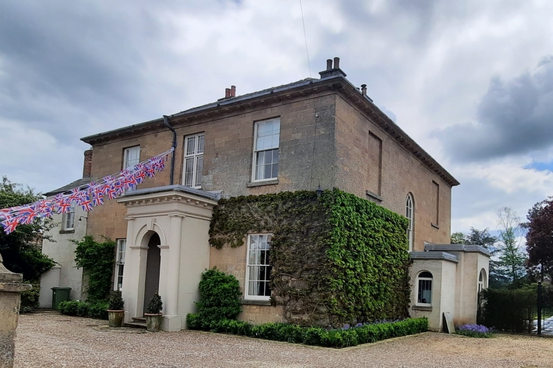
House. Early C19. Ashlar. Hipped slate roof. 3 rendered
stacks. Modillion eaves cornice. Set on a plinth. 2 storeys, 3
bays. Central painted later C19 porch, attached entrance with
moulded archivolt and keystone, flanked by single attached Doric
columns supporting an entablature with dentil cornice. Inner
part glazed and panelled door with decorative overlight. Either
side are single glazing bar sashes. Above, single central cross
casement flanked by single glazing bar sashes. To the right, set
back, is a C20 render and felt single storey, single bay wing
with single arched casement. Above, in the main wall of the
house, is a single central dropped arched stairlight with arched
glazing bars. To the left of the main front, set back, is a
render over red brick and slate lower 2 storey, 2 bay wing with
left red brick gable stack. Doorway with 6 panelled door and
decorative glazing bar fanlight. Above left is a single glazing
bar sash.
Listing NGR: SK6500756484
External links are from the relevant listing authority and, where applicable, Wikidata. Wikidata IDs may be related buildings as well as this specific building. If you want to add or update a link, you will need to do so by editing the Wikidata entry.


Other nearby listed buildings
