Approximate Location Map
Large Map »
Latitude: 53.1085 / 53°6'30"N
Longitude: -0.9928 / 0°59'34"W
OS Eastings: 467522
OS Northings: 357285
OS Grid: SK675572
Mapcode National: GBR 9HC.1TX
Mapcode Global: WHFHD.Q4F9
Plus Code: 9C5X4254+9V
Entry Name: Kirklington Mill and Road Bridge
Listing Date: 25 June 1976
Grade: II
Source: Historic England
Source ID: 1285767
English Heritage Legacy ID: 242177
ID on this website: 101285767
Location: Kirklington, Newark and Sherwood, Nottinghamshire, NG22
County: Nottinghamshire
District: Newark and Sherwood
Civil Parish: Kirklington
Built-Up Area: Kirklington
Traditional County: Nottinghamshire
Lieutenancy Area (Ceremonial County): Nottinghamshire
Church of England Parish: Kirklington
Church of England Diocese: Southwell and Nottingham
Tagged with: Road bridge
SK 65 NE KIRKLINGTON SOUTHWELL ROAD
(east side)
3/122 Kirklington Mill
25.6.76 and road bridge
G.V. II
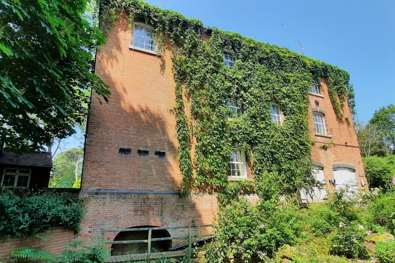
Water mill. Mid C19. Red brick with some blue brick and ashlar.
Plain tile roof. Raised eaves band of red and blue brick. Set on
a plinth, deeper to the rear with blue brick band over. 3
storeys plus garret, 4 bays. Doorway with plank door. Either
side are single window openings. The bay on the far right being
blind. Above, narrow doorway with plank door, to the left is a
single window opening and to the right 2 window openings.
Above are 3 window openings over those of the first floor.
Windows originally with 16 pane cast iron glazing bars. All
openings under blue brick segmental arches with keystones.
Above, breaking the eaves, is a single central gabled plank
hoist. There are 7 round tie plates. Rear has 2 similar window
openings on each floor, 8 round tie plates and to the lower left,
set into the plinth, a single depressed archway over the water
race. In front of the mill is a road bridge with ashlar coped
brick parapet and beyond the mill pond with iron sluice gate.
Interior not inspected, but reputed to contain no machinery.
Listing NGR: SK6752257285
External links are from the relevant listing authority and, where applicable, Wikidata. Wikidata IDs may be related buildings as well as this specific building. If you want to add or update a link, you will need to do so by editing the Wikidata entry.


Other nearby listed buildings
