Approximate Location Map
Large Map »
Latitude: 53.2236 / 53°13'25"N
Longitude: -1.0766 / 1°4'35"W
OS Eastings: 461748
OS Northings: 370017
OS Grid: SK617700
Mapcode National: GBR 9FP.YDC
Mapcode Global: WHFGS.F7KJ
Plus Code: 9C5W6WFF+C9
Entry Name: Sherwood House and Boundary Wall and Railings
Listing Date: 11 August 1961
Grade: II
Source: Historic England
Source ID: 1045474
English Heritage Legacy ID: 242234
ID on this website: 101045474
Location: Budby, Newark and Sherwood, Nottinghamshire, NG22
County: Nottinghamshire
District: Newark and Sherwood
Civil Parish: Perlethorpe cum Budby
Traditional County: Nottinghamshire
Lieutenancy Area (Ceremonial County): Nottinghamshire
Church of England Parish: Edwinstowe
Church of England Diocese: Southwell and Nottingham
Tagged with: Building
SK 67 SW
1/92
11.8.61
PERLETHORPE CUM BUDBY
THE LANE
(south side)
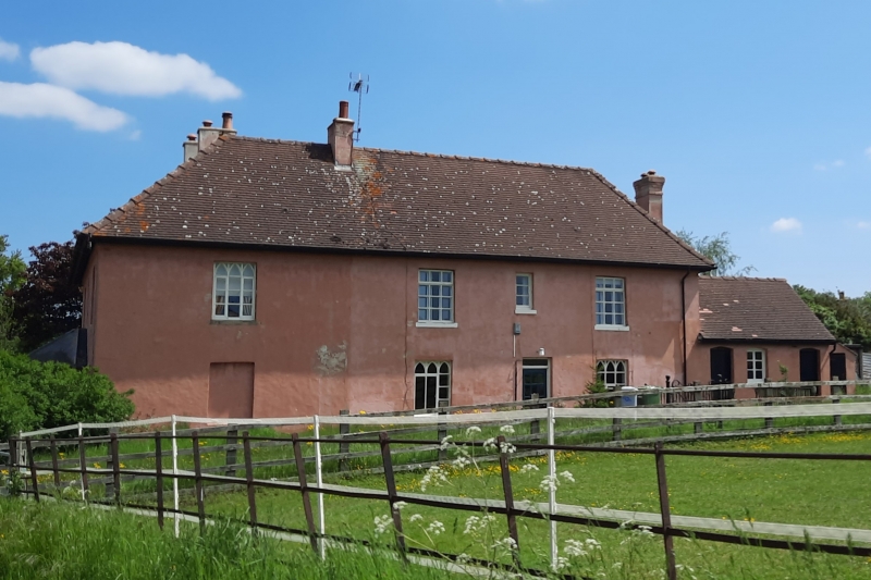
Sherwood House and boundary wall and railings
G.V.
II
House. Early C19. Large rear addition late C19. Now 2 houses.
Brick, rendered, with hipped and gabled plain tile and leaded
roofs. Stone plinth. Shaped eaves brackets. 4 ridge stacks. 2
storeys. 3 bays wide by 5 bays deep. Windows are mainly Gothick
casements. North front has central hipped, canted leaded porch
with 3 round headed openings. Half-glazed door. Flanked by
single casements. Above, 3 casements, the central one smallest.
Adjoining dwarf stone boundary wall carrying iron railing and
gate. West side has off-centre door flanked by single casements.
Beyond, to left, blocked opening. Beyond, to right, late C19
addition, single storey, 2 bays, with off-centre casement flanked
by single doors. All with segmental heads. Above, 4 different
casements. South end has to east, 2 C20 additions, 2 storeys,
single bay. This building is part of the complete Estate Village
laid out by Earl Manvers of Thoresby Park 1807-1812.
Listing NGR: SK6174870017
External links are from the relevant listing authority and, where applicable, Wikidata. Wikidata IDs may be related buildings as well as this specific building. If you want to add or update a link, you will need to do so by editing the Wikidata entry.


Other nearby listed buildings
