Approximate Location Map
Large Map »
Latitude: 53.2257 / 53°13'32"N
Longitude: -1.0762 / 1°4'34"W
OS Eastings: 461768
OS Northings: 370252
OS Grid: SK617702
Mapcode National: GBR 9FP.QR0
Mapcode Global: WHFGS.F5RX
Plus Code: 9C5W6WGF+7G
Entry Name: North Farmhouse
Listing Date: 11 August 1961
Last Amended: 20 June 1986
Grade: II
Source: Historic England
Source ID: 1045477
English Heritage Legacy ID: 242243
ID on this website: 101045477
Location: Budby, Newark and Sherwood, Nottinghamshire, NG22
County: Nottinghamshire
District: Newark and Sherwood
Civil Parish: Perlethorpe cum Budby
Traditional County: Nottinghamshire
Lieutenancy Area (Ceremonial County): Nottinghamshire
Church of England Parish: Edwinstowe
Church of England Diocese: Southwell and Nottingham
Tagged with: Farmhouse
PERLETHORPE MAIN STREET
SK 67 SW
CUM BUDBY (formerly Carburton
Road) (north side)
1/101 North Farmhouse
11.8.61
G.V. II
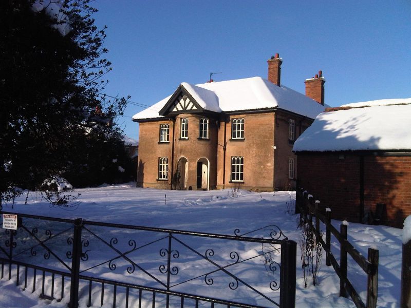
Farmhouse. c.1807. Probably by William Wilkins Jnr. Brick and
stone, rendered, with hipped plain tile roofs. Stone and brick
plinth, rendered. Partial first floor band. 2 ridge and single
external gable stacks. 2 storeys, 3 bays. Square plan with rear
wing. Windows are mainly Gothick casements. South front has
central 2 storey half-round bay, with mock timber framed gable.
3 round headed openings with half glazed door. Flanked by single
casements. Above, central bay has 3 small casements, flanked by
single larger casements. West front has to left, plain casement
and to its right, 2 Gothick casements. Beyond boundary wall,
another casement. Above, 3 Gothick casements. West gable has a
single C20 casement on each floor. East front has to left, 3
casements and to their right, door. To right again, C20
casement. Above, 4 casements, one smaller. North front has to
left, segmental headed recess containing door with Gothick
tracery. To right, C20 casement. Above to right, C20 casement.
Late C19 north wing addition has to north a casement and to west,
a Yorkshire sash. This building is part of the complete Estate
Village laid out by Earl Manvers of Thoresby Park 1807-1812.
Listing NGR: SK6176870252
External links are from the relevant listing authority and, where applicable, Wikidata. Wikidata IDs may be related buildings as well as this specific building. If you want to add or update a link, you will need to do so by editing the Wikidata entry.


Other nearby listed buildings
