Approximate Location Map
Large Map »
Latitude: 53.223 / 53°13'22"N
Longitude: -1.0715 / 1°4'17"W
OS Eastings: 462090
OS Northings: 369957
OS Grid: SK620699
Mapcode National: GBR 9FP.ZX1
Mapcode Global: WHFGS.J70Z
Plus Code: 9C5W6WFH+6C
Entry Name: Budby Castle
Listing Date: 11 August 1961
Last Amended: 20 June 1986
Grade: II
Source: Historic England
Source ID: 1045478
English Heritage Legacy ID: 242245
ID on this website: 101045478
Location: Budby, Newark and Sherwood, Nottinghamshire, NG22
County: Nottinghamshire
District: Newark and Sherwood
Civil Parish: Perlethorpe cum Budby
Traditional County: Nottinghamshire
Lieutenancy Area (Ceremonial County): Nottinghamshire
Church of England Parish: Perlethorpe
Church of England Diocese: Southwell and Nottingham
Tagged with: Castle
SK 66 NW
3/103
11.8.61
PERLETHORPE CUM BUDBY
off MAIN STREET
(formerly Carburton Road)
(east side)
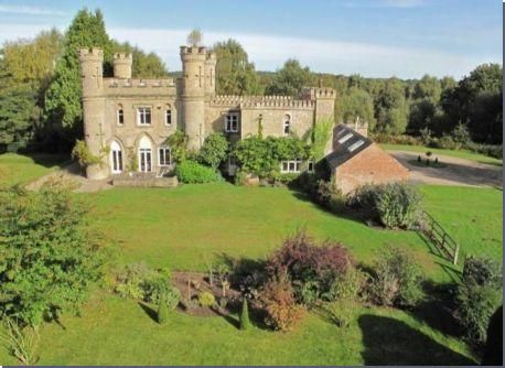
Budby Castle (Formerly listed under Budby)
II
Eye catcher and estate cottage. 1789. Possibly by John Carr for
the Earl Manvers. Dressed stone and brick, with slate roofs.
Ashlar dressings. Castellated style. 3 stacks in corner towers.
Plinth, moulded string course and eaves, crenellated parapet. 2
storeys, 3 unequal bays. 2 square blocks with round corner
towers. Windows are Gothick, Moorish and plain casements.
Square windows have projecting architraves. Most windows have
hood moulds. Main north front has to left, crenellated screen
wall with a hatch. To its right, 2 storey block has to left
octagonal corner tower, central square tower and to right, square
corner tower. To left, pointed door with hood mould. To right,
Gothick casement. Above, to left, unglazed opening. To its
right, casement and to right again, Moorish casement. Taller
block, to right again, has 4 crenellated 3 storey corner towers
with blind crosslets. Central Gothick casement flanked by single
Moorish casements. Above, central casement flanked by single
Moorish arched openings. West front has central blank pointed
opening flanked by single Moorish arched openings, that to right
with casement. Above, blank central panel flanked by single
Moorish casements. South front has to left, pointed opening with
inserted French window. Flanked to left by pointed glazed door
with Gothick overlight, and to right by C20 casement. Above,
central square casement flanked by single Moorish casements. To
right, wall with pointed glazed door with Gothick overlight.
Above, a square casement. Projecting lower block to right, has
square corner towers, that to west with a casement. Large C20
casement and above, central Moorish casement. Adjoining small
boundary wall has chamfered coping. To right again, C19
outbuildings, single storey, 4 bays. To east, 2 pairs of garage
doors and to right, square hatch. This building is part of the
complete Estate Village laid out by Earl Manvers of Thoresby Park
1807-1812.
Listing NGR: SK6209069957
External links are from the relevant listing authority and, where applicable, Wikidata. Wikidata IDs may be related buildings as well as this specific building. If you want to add or update a link, you will need to do so by editing the Wikidata entry.


Other nearby listed buildings
