Approximate Location Map
Large Map »
Latitude: 53.1019 / 53°6'6"N
Longitude: -0.7856 / 0°47'8"W
OS Eastings: 481402
OS Northings: 356766
OS Grid: SK814567
Mapcode National: GBR CL9.D7D
Mapcode Global: WHFHH.X92C
Plus Code: 9C5X4627+QP
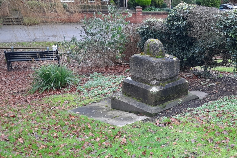
Entry Name: Village Cross
Listing Date: 15 October 1984
Grade: II
Source: Historic England
Source ID: 1369953
English Heritage Legacy ID: 242700
ID on this website: 101369953
Location: Winthorpe, Newark and Sherwood, Nottinghamshire, NG24
County: Nottinghamshire
District: Newark and Sherwood
Civil Parish: Winthorpe
Built-Up Area: Winthorpe
Traditional County: Nottinghamshire
Lieutenancy Area (Ceremonial County): Nottinghamshire
Church of England Parish: Winthorpe
Church of England Diocese: Southwell and Nottingham
Tagged with: High cross
SK 85 NW
1/66
WINTHORPE
HOLME LANE (east side)
Village Cross
G.V.
II
Village cross. C14. Stone and brick. Stone socket and single piece of
shaft, set on a brick plinth.
Listing NGR: SK8140256766
External links are from the relevant listing authority and, where applicable, Wikidata. Wikidata IDs may be related buildings as well as this specific building. If you want to add or update a link, you will need to do so by editing the Wikidata entry.


Other nearby listed buildings
