Approximate Location Map
Large Map »
Latitude: 53.127 / 53°7'37"N
Longitude: -0.8397 / 0°50'22"W
OS Eastings: 477737
OS Northings: 359494
OS Grid: SK777594
Mapcode National: GBR BJH.Y8T
Mapcode Global: WHFH9.2NFN
Plus Code: 9C5X45G6+Q4
Entry Name: Manor Farm House and Adjoining Boundary Wall
Listing Date: 19 September 1985
Grade: II
Source: Historic England
Source ID: 1369956
English Heritage Legacy ID: 242715
ID on this website: 101369956
Location: Bathley, Newark and Sherwood, Nottinghamshire, NG23
County: Nottinghamshire
District: Newark and Sherwood
Civil Parish: Bathley
Traditional County: Nottinghamshire
Lieutenancy Area (Ceremonial County): Nottinghamshire
Church of England Parish: North Muskham
Church of England Diocese: Southwell and Nottingham
Tagged with: Farmhouse
SK 75 NE BATHLEY MAIN STREET
(west side)
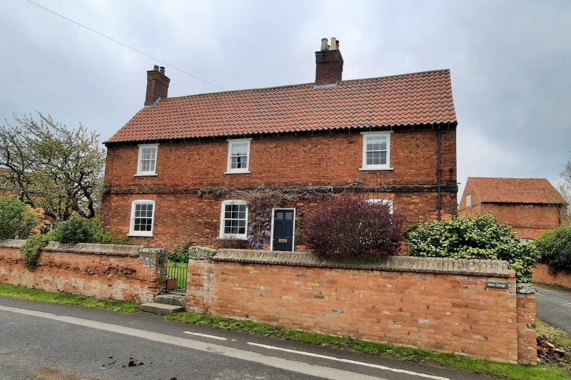
7/12 Manor Farm House
and adjoining
boundary wall
II
Farmhouse. c.1811-1818. Probably built for John Capps. Brick
with steep pitched C20 pantile roof. Rubble plinth, first floor
band, dentillated eaves, single gable and single ridge stacks, 2
storeys plus garrets, 3 bays, L-plan. Main east front has off-
centre door with keystoned rubbed brick head flanked to left by 2
and to right by single glazing bar sashes with segmental heads.
Above, 3 glazing bar sashes with timber lintels. North front has
to left a small light, and to its right a similar light and door
with segmental head. Above, to left, unglazed opening, and above
again, a casement. South front has to left a single storey lean-
to with a casement, and above, another casement. Adjoining
ramped brick boundary wall with half-round and shaped brick
copings and a pair of square gatepiers with dressed stone caps.
Information from the researches of Mr. F. A. Barnes.
Listing NGR: SK7773759494
External links are from the relevant listing authority and, where applicable, Wikidata. Wikidata IDs may be related buildings as well as this specific building. If you want to add or update a link, you will need to do so by editing the Wikidata entry.


Other nearby listed buildings
