Approximate Location Map
Large Map »
Latitude: 51.871 / 51°52'15"N
Longitude: -1.2943 / 1°17'39"W
OS Eastings: 448686
OS Northings: 219390
OS Grid: SP486193
Mapcode National: GBR 7W6.PM2
Mapcode Global: VHCX7.J74K
Plus Code: 9C3WVPC4+97
Entry Name: Oxford Canal Bridge at Pigeons Lock
Listing Date: 9 December 1987
Grade: II
Source: Historic England
Source ID: 1200266
English Heritage Legacy ID: 243456
ID on this website: 101200266
Location: Cherwell, Oxfordshire, OX5
County: Oxfordshire
District: Cherwell
Civil Parish: Kirtlington
Traditional County: Oxfordshire
Lieutenancy Area (Ceremonial County): Oxfordshire
Church of England Parish: Kirtlington
Church of England Diocese: Oxford
Tagged with: Bridge
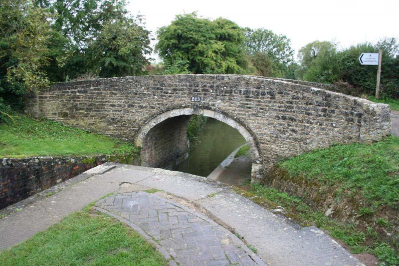
SP41NE KIRTLINGTON OXFORD CANAL
8/71 Canal bridge at Pigeons Lock
- II
Canal bridge. Late C18. Coursed squared limestone. Depressed arch has projecting
imposts and keyblock linked to a surrounding dripmould; solid parapets rise over
the arch and curve outwards to rectangular piers. Both sides retain cast-iron
plates inscribed "213".
Listing NGR: SP4868619390
External links are from the relevant listing authority and, where applicable, Wikidata. Wikidata IDs may be related buildings as well as this specific building. If you want to add or update a link, you will need to do so by editing the Wikidata entry.


Other nearby listed buildings
