Approximate Location Map
Large Map »
Latitude: 51.8966 / 51°53'47"N
Longitude: -1.1515 / 1°9'5"W
OS Eastings: 458480
OS Northings: 222344
OS Grid: SP584223
Mapcode National: GBR 8XJ.3P4
Mapcode Global: VHCX4.0L3F
Plus Code: 9C3WVRWX+J9
Entry Name: 29 and 29A, Market Square
Listing Date: 20 March 1970
Grade: II
Source: Historic England
Source ID: 1046469
English Heritage Legacy ID: 243567
ID on this website: 101046469
Location: Bicester, Cherwell, Oxfordshire, OX26
County: Oxfordshire
District: Cherwell
Civil Parish: Bicester
Built-Up Area: Bicester
Traditional County: Oxfordshire
Lieutenancy Area (Ceremonial County): Oxfordshire
Church of England Parish: Bicester with Caversfield
Church of England Diocese: Oxford
Tagged with: Building
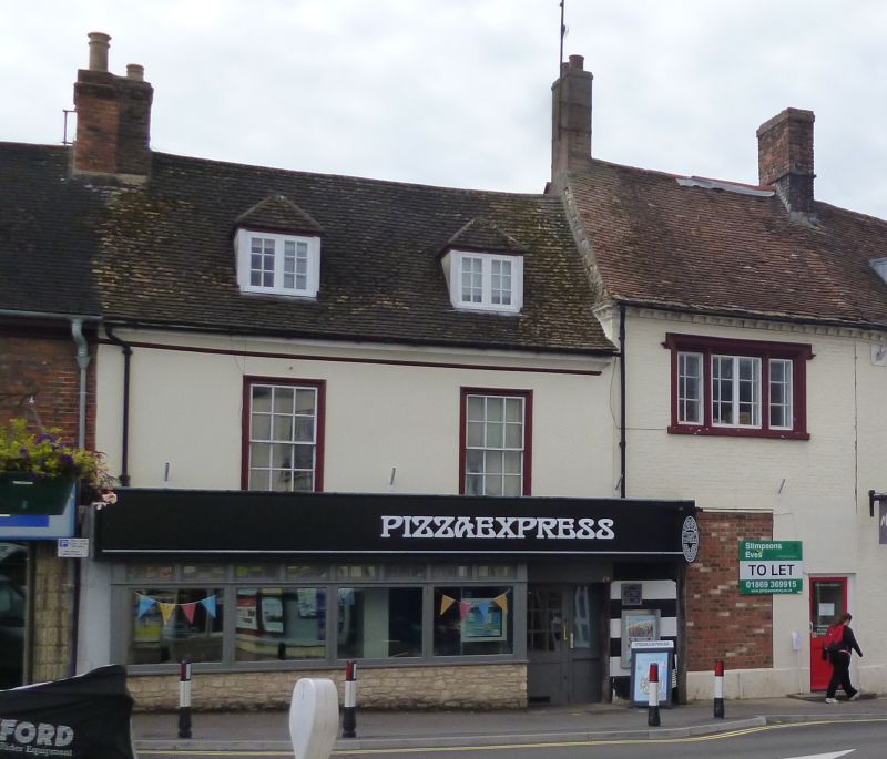
BICESTER MARKET SQUARE
SP5822S (South side)
3/92 Nos.29 and 29A
20/03/70
BY II
Shop and dwelling. Early C18, possibly partly earlier, and early C19.
Part-rendered brick, limestone rubble, and chequer brick with yellow headers;
plain-tile and Welsh-slate roofs with brick stacks. 4 ranges surrounding a
courtyard. 2 storeys plus attics and 2 storeys. No.29, to left, has a rendered
2-window front with a moulded eaves cove and two 12-pane first-floor sashes; the
sleep-pitched roof has 2 hipped roof dormers. The taller brick bay to right
(No.29A) has a large elaborately-moulded stone-mullioned window at first floor
(probably C19), and the moulded dentil cornice continues from that of No.28
(q.v.) to right. C20 shop front extends across both sections. The 2-storey
3-window range to rear of No.29A has a rubble ground floor, above which is
early-C19 chequer brickwork with very large sashes. Rubble and brick outbuilding
ranges to rear of No.29, probably mostly C18, form the other 2 sides of the
courtyard. Interior: No.29 has closely-spaced heavy chamfered beams at ground
floor which could be C16/early C17. No.29A originally formed part of Ambrosden
House (q.v. No.28) to right.
(V.C.H.: Oxfordshire, Vol.VI, p.18).
Listing NGR: SP5848022336
External links are from the relevant listing authority and, where applicable, Wikidata. Wikidata IDs may be related buildings as well as this specific building. If you want to add or update a link, you will need to do so by editing the Wikidata entry.


Other nearby listed buildings
