Approximate Location Map
Large Map »
Latitude: 51.7524 / 51°45'8"N
Longitude: -1.2469 / 1°14'49"W
OS Eastings: 452079
OS Northings: 206238
OS Grid: SP520062
Mapcode National: GBR 8Z4.3JY
Mapcode Global: VHCXV.B6NX
Plus Code: 9C3WQQ23+X6
Entry Name: Magdalen College, the Presidents Lodging
Listing Date: 12 January 1954
Grade: II
Source: Historic England
Source ID: 1199761
English Heritage Legacy ID: 244988
ID on this website: 101199761
Location: Headington Hill, Oxford, Oxfordshire, OX1
County: Oxfordshire
District: Oxford
Town: Oxford
Electoral Ward/Division: Holywell
Parish: Non Civil Parish
Built-Up Area: Oxford
Traditional County: Oxfordshire
Lieutenancy Area (Ceremonial County): Oxfordshire
Church of England Parish: Oxford St Mary the Virgin with St Cross with St Peter-in-the-East,
Church of England Diocese: Oxford
Tagged with: Architectural structure
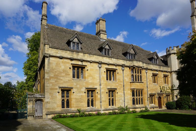
MAGDALEN COLLEGE
1.
1485
The President's Lodging
SP 5206 SW 10/419E 12.1.54.
II
2.
Rebuilt in 1886-8 in Taynton and Milton stone but retains on North an early
C16 kitchen wing of one storey.
Listing NGR: SP5207906238
External links are from the relevant listing authority and, where applicable, Wikidata. Wikidata IDs may be related buildings as well as this specific building. If you want to add or update a link, you will need to do so by editing the Wikidata entry.


Other nearby listed buildings
