Approximate Location Map
Large Map »
Latitude: 51.7555 / 51°45'19"N
Longitude: -1.2633 / 1°15'47"W
OS Eastings: 450948
OS Northings: 206570
OS Grid: SP509065
Mapcode National: GBR 7XL.Z9P
Mapcode Global: VHCXV.240K
Plus Code: 9C3WQP4P+6M
Entry Name: Worcester College, Boundary Wall on Walton Street
Listing Date: 28 June 1972
Grade: II
Source: Historic England
Source ID: 1184331
English Heritage Legacy ID: 245212
ID on this website: 101184331
Location: Jericho, Oxford, Oxfordshire, OX1
County: Oxfordshire
District: Oxford
Electoral Ward/Division: Carfax
Parish: Non Civil Parish
Built-Up Area: Oxford
Traditional County: Oxfordshire
Lieutenancy Area (Ceremonial County): Oxfordshire
Church of England Parish: Oxford St Barnabas with St Thomas the Martyr
Church of England Diocese: Oxford
Tagged with: Architectural structure
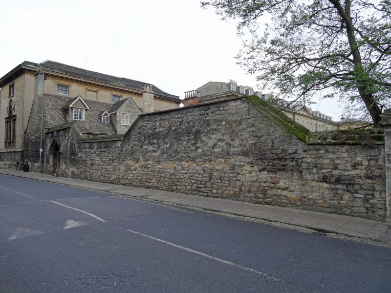
WORCESTER COLLEGE
1.
1485
Boundary wall on
Walton Street
SP 5006 NE 4/132H
II
2.
Stone rubble of uncertain date.
Listing NGR: SP5094806570
External links are from the relevant listing authority and, where applicable, Wikidata. Wikidata IDs may be related buildings as well as this specific building. If you want to add or update a link, you will need to do so by editing the Wikidata entry.


Other nearby listed buildings
