Approximate Location Map
Large Map »
Latitude: 51.7549 / 51°45'17"N
Longitude: -1.2531 / 1°15'11"W
OS Eastings: 451652
OS Northings: 206508
OS Grid: SP516065
Mapcode National: GBR 8YY.VC6
Mapcode Global: VHCXV.75D1
Plus Code: 9C3WQP3W+XQ
Entry Name: 1, Bath Place
Listing Date: 12 January 1954
Grade: II
Source: Historic England
Source ID: 1299843
English Heritage Legacy ID: 245312
ID on this website: 101299843
Location: Oxford, Oxfordshire, OX1
County: Oxfordshire
District: Oxford
Electoral Ward/Division: Holywell
Parish: Non Civil Parish
Built-Up Area: Oxford
Traditional County: Oxfordshire
Lieutenancy Area (Ceremonial County): Oxfordshire
Church of England Parish: Oxford St Mary the Virgin with St Cross with St Peter-in-the-East,
Church of England Diocese: Oxford
Tagged with: Building
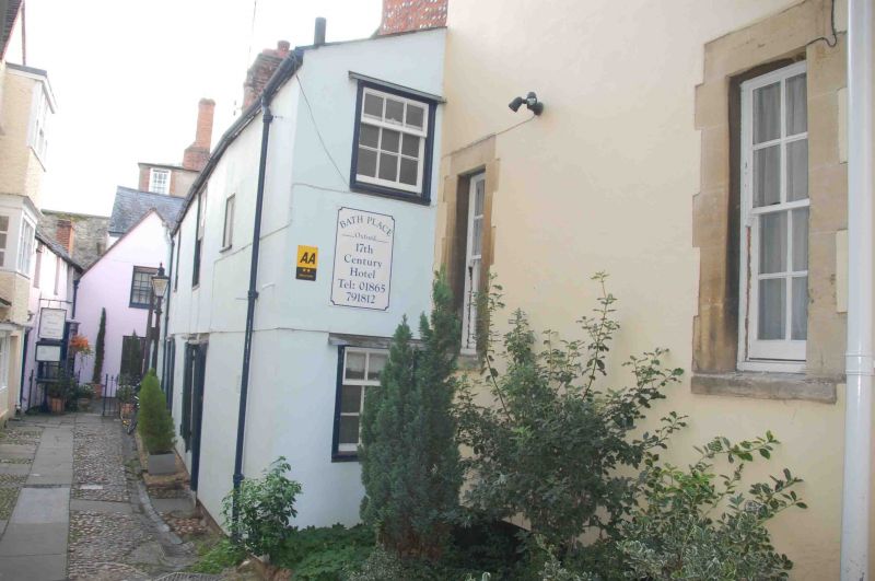
BATH PLACE
1.
1485
(West Side)
No 1
SP 5106 NE 6/256 12.1.54.
II GV
2.
House. Possibly C17 in origin and altered in C18. 2 storeys. Plastered
timber-framing. Brick stack. C18 windows, those on the ground floor with
shutters.
Nos 1 to 7 (consec) form a group.
Listing NGR: SP5165206508
External links are from the relevant listing authority and, where applicable, Wikidata. Wikidata IDs may be related buildings as well as this specific building. If you want to add or update a link, you will need to do so by editing the Wikidata entry.


Other nearby listed buildings
