Approximate Location Map
Large Map »
Latitude: 51.7524 / 51°45'8"N
Longitude: -1.2754 / 1°16'31"W
OS Eastings: 450117
OS Northings: 206218
OS Grid: SP501062
Mapcode National: GBR 7XS.2CG
Mapcode Global: VHCXT.V63X
Plus Code: 9C3WQP2F+XV
Entry Name: Seven Arches Bridge
Listing Date: 12 January 1954
Grade: II
Source: Historic England
Source ID: 1047337
English Heritage Legacy ID: 245338
ID on this website: 101047337
Location: Osney, Oxford, Oxfordshire, OX2
County: Oxfordshire
District: Oxford
Electoral Ward/Division: Jericho and Osney
Parish: Non Civil Parish
Built-Up Area: Oxford
Traditional County: Oxfordshire
Lieutenancy Area (Ceremonial County): Oxfordshire
Church of England Parish: Oxford St Frideswide with Binsey
Church of England Diocese: Oxford
Tagged with: Bridge
1.
1485
SP 50 NW
24/688
BOTLEY ROAD
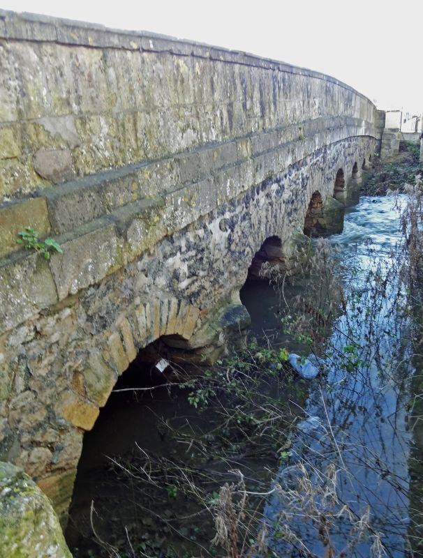
Seven Arches Bridge
II
2.
Originally probably C16 or earlier, widened in 1960 on the South side when
it was much rebuilt. 7 stone arches, plain parapet walls. North face rubble
with cutwater and ashlar parapet. South face all ashlar with keystones.
Listing NGR: SP5011706218
External links are from the relevant listing authority and, where applicable, Wikidata. Wikidata IDs may be related buildings as well as this specific building. If you want to add or update a link, you will need to do so by editing the Wikidata entry.


Other nearby listed buildings
