Approximate Location Map
Large Map »
Latitude: 51.7541 / 51°45'14"N
Longitude: -1.2575 / 1°15'27"W
OS Eastings: 451347
OS Northings: 206418
OS Grid: SP513064
Mapcode National: GBR 8YY.T2G
Mapcode Global: VHCXV.551M
Plus Code: 9C3WQP3R+JX
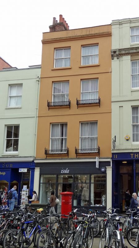
Entry Name: 12, Broad Street
Listing Date: 28 June 1972
Grade: II
Source: Historic England
Source ID: 1047344
English Heritage Legacy ID: 245350
ID on this website: 101047344
Location: Oxford, Oxfordshire, OX1
County: Oxfordshire
District: Oxford
Electoral Ward/Division: Carfax
Parish: Non Civil Parish
Built-Up Area: Oxford
Traditional County: Oxfordshire
Lieutenancy Area (Ceremonial County): Oxfordshire
Church of England Parish: Oxford St Michael and St Martin and All Saints
Church of England Diocese: Oxford
Tagged with: Building
BROAD STREET
1.
1485
(South Side)
No 12
SP 5106 SW 8/173
II GV
2.
House and Shop. Early Cl9 4-storeyed stucco with bands at each floor. Small
moulded cornice, small parapet, a red brick stack and 2 sash windows, modern
shopfront.
Nos 6 to 25 (consec) form a group.
Listing NGR: SP5134606406
External links are from the relevant listing authority and, where applicable, Wikidata. Wikidata IDs may be related buildings as well as this specific building. If you want to add or update a link, you will need to do so by editing the Wikidata entry.


Other nearby listed buildings
